Eucla basement stratigraphic drilling program results release
The Eucla basement 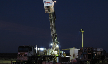 stratigraphic drilling program, funded through the Exploration Incentive Scheme (EIS), was established to investigate the greenfields Madura and Coompana basement provinces that lie between the Albany–Fraser Orogen and Gawler Craton, beneath up to 500 m of cover rocks in the Bight and Eucla Basins, Western Australia.
The workshop will include presentations from the Geological Survey of Western Australia, Curtin University and First Drilling.
Topics include:
- Drilling techniques and core acquisition
- Lithological and structural features
- Sulfides, veins and alteration
- Implications for geophysical data interpretations
- Geochronology
- Geochemistry, isotopes and crustal evolution
- Tectonic settings and implications for geodynamics and prospectivity
- Geology of the cover sequences
Date Thursday 10 September 2015
Time 8.30 am – 5.00 pm
Venue Hyatt Hotel
Location East Perth
Cost FREE but registration is essential.
To register, contact Deenikka Preedy (deenikka.preedy@dmp.wa.gov.au) or 9222 3634. Please also indicate whether you wish to attend the public core viewing of representative sections on Monday 14 September 2015, at the Perth Core Library, Carlisle
The schedule of presentations will soon be available on the DMP website. Short abstracts will be available on the day, and will be posted on the website afterwards.
Stratigraphic drilling program details
During 2013 and 2014 eight diamond holes were successfully drilled, providing 1560 m of high-quality, oriented HQ basement core, and PQ diamond and RC chips of cover rocks from selected holes. The site locations were chosen to investigate and map geophysical domains interpreted in magnetic and gravity data, rather than as specific targets, and to investigate potential host rocks to known mafic intrusions (i.e. Loongana, Haig and Serpent).
Given the large variation in lithologies and structures, both within individual cores and between cores, this drilling program is on track to greatly increase our knowledge of the basement provinces that are missing links in understanding Proterozoic Australian geology. Combined with work on existing EIS co-funded and donated company cores, the new drillcores also provide insight into the prospectivity of the vast region that lies beneath the Nullarbor Plain.
The stratigraphic drilling program has also provided valuable experience and knowledge of the challenging ground conditions associated with drilling in the Nullarbor region. Both RC and mud-rotary techniques have been trialled and assessed as alternative techniques for getting through the cover to basement.
For more information, contact Catherine Spaggiari (catherine.spaggiari@dmp.wa.gov.au).
GSWA Training 2015 — Perth prospectors’ session on 9 July
The Geological Survey of Western Australia (GSWA) offers FREE training 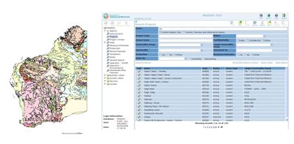 in its databases and online systems. The training is in the form of a presentation with hands-on interaction in most systems.
Topics include:
- navigating the Department of Mines and Petroleum’s (DMP) website
- searching for geoscience publications
- finding digital datasets using the Data and Software Centre
- searching for open-file mineral exploration reports using WAMEX
- searching the mineral drillholes and geochemistry databases
- bringing it all together with the interactive map viewer, GeoVIEW.WA and GeoMap.WA, a standalone GIS viewer for Windows.
PERTH
The Perth training has been divided into separate sessions: one for prospectors, and one for mining companies/geologists.
Venue: Mineral House, 100 Plain Street, East Perth
- Thursday 9 July — prospectors only (9.30 am – 12.30 pm)
- Thursday 29 October (prospectors in the morning, mining companies/geologists in the afternoon)
KALGOORLIE
The Kalgoorlie training is open to anyone.
Venue: Room 102 (computer lab), Goldfields Institute of Technology, Centre for Engineering and Mining Training (CEMT), Australian Prospectors and Miners Hall of Fame, Kalgoorlie
- Thursday 5 November
Register
To register for this free training, send an email to publications@dmp.wa.gov.au including your details (name, company name, telephone number), the location and date of the training you wish to attend.
Seeing the sites on Rottnest
Did you know 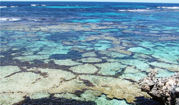 that as well as sun, sand, and surf, the little rocky island of Rottnest has some geological features of international significance?
The Geological Survey of Western Australia recently published a pamphlet on some of the world-class geology found on Rottnest to coincide with a Forum Advocating Cultural & Eco-Tourism Inc (FACET) conference in Perth and on Rottnest on Geotourism — Tourism Down Under. Using the pamphlet, you can visit nine geological sites round the island from West End (in the far west) to The Basin (just round the corner from Thomson Bay).
Author Bob Gozzard draws attention to shoreline platforms and notches that are +2.4, +1.1, and +0.5 metres above present day sea level.
At Fairbridge Bluff ancient corals grew 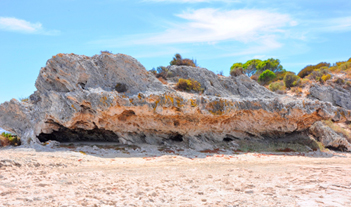 about 125 000 years ago — and there is a similar modern coral reef growing today offshore from Parker Point. A snorkel, mask, and fins will give you a great view underwater of about 25 species of coral.
‘Paddy-field’ terraces (so named as they look just like paddy fields!) and algal polygons are beautifully developed at Wilson Bay. The algal polygons are irregular hexagons and pentagons outlined by the growth of brown seaweed, probably due to the grazing habits of herbivorous reef fish, which seem to be responsible for the creation and maintenance of the polygon boundaries.
The free full-colour pamphlet is available from Mineral House, from the Rottnest Visitor Centre, and from other local Visitor Centres catering to the Rottnest visitor. It can also be downloaded free from the DMP eBookshop.
For more information, contact Jean Johnston (jean.johnston@dmp.wa.gov.au).
New releases
REPORTS
Report 139 Geosequestration potential of the Carboniferous–Permian Grant Group and Permian Poole Sandstone, northwest Canning Basin, Western Australia
by Dentith, MC, Dent, LM, George, AD, Langhi, L, Sanchez, G, Seyedmehdi, Z, Strand, J, Vaslin, A and Zaheer R
Report 142 Mineral prospectivity of the King Leopold Orogen and Lennard Shelf: analysis of potential field data in the west Kimberley region
by Lindsay, MD, Aitken, AR, Ford, A, Dentith, MC, Hollis, JA and Tyler IM
This consists of a PDF of the Report with appendices, including PDFs, tables as MS Excel spreadsheets, and spatially located GIS data used to construct predictor and prospectivity maps as compressed files that can be downloaded free from eBookshop
Report 146 Pressure–temperature–time evolution of the Mutherbukin Tectonic Event, Capricorn Orogen
by Korhonen, FJ, Johnson, SP, Fletcher, IR, Rasmussen, B, Sheppard, S, Muhling, JR, Dunkley, DJ, Wingate, MTD, Roberts, MP and Kirkland, CL
Report 150 Building the crust of the Albany-Fraser Orogen: constraints from granite geochemistry
by Smithies, RH, Spaggiari, CV and Kirkland CL
Report 151 Early evolution of the Pilbara Craton from hafnium isotopes in detrital and inherited zircons
by Kemp, AIS, Hickman, AH and Kirkland, CL
Appendices for this Report are provided as accompanying compressed files that can be downloaded free from eBookshop
REPORT DATA PACKAGES
Report 132 District-scale targeting for gold in the Yilgarn Craton: Part 2 of the Yilgarn Gold Exploration Targeting Atlas
by Witt, WK, Ford, A, and Hanrahan, B
This product is a USB containing:
- Report 132 as a PDF document (also available as a separate free downloadable PDF from eBookshop)
- A digital Appendix to Report 132, consisting of a complete set of tabulated results and charts of spatial analyses, supplied as MS Excel spreadsheets
ESRI ArcGIS shapefiles consisting of:
- targeting criteria features
- buffers created for containment and proximity analyses
- gold deposits intersected by buffers
Cost: $55
RECORDS
Record 2014/1 Geological Survey work program for 2015–15 and beyond
Record 2014/6 Albany-Fraser Orogen seismic and MT workshop 2014 (includes four plates)
Compiled by Spaggiari, CV and Tyler, IM
Record 2015/4 Tectonite type: their formation and significance, map production, field relationships and petrography
by Tomkins, AE
Record 2015/5 Temporal constraints on magmatism, granulite-facies metamorphism, and gold mineralization of the Hercules Gneiss, Tropicana Zone, Albany–Fraser Orogen
by Kirkland, CL, Spaggiari, CV, Smithies, RH, Wingate, MTD, Sweetapple, MT, Watkins, R, Tessalina, S, and Creaser, RC
Record 2015/7 Limesand and limestone resources of southern WA
This Record is available as a PDF that can be downloaded free from eBookshop. The Record is also part of the Record Data Package.
NON-SERIES BOOKS
Western Australia atlas of mineral deposits and petroleum fields 2015
by Cooper, RW, Abeysinghe, PB, Strong, CA, Day, LJ, and Irimies, F
NON-SERIES BOOKS
Rottnest Island — a geology guide
by Gozzard, JR
Subscribe to Fieldnotes
 Fieldnotes is a quarterly publication released by GSWA to provide the State's exploration industry and other geoscientists with an update on our latest work and ongoing programs. The publication provides updates on other GSWA products and services and is available free from the Information Centre located on the first floor of Mineral House, 100 Plain Street, East Perth 6004. Find past issues of Fieldnotes here or subscribe to receive a hard copy by emailing publications@dmp.wa.gov.au.
Access GSWA products
You can view and download maps, reports, and digital information free of charge from our website.
Click on these links to take you to the download or launch page for that product:
- Geoscience information, maps and reports
- GIS versions of maps and links to web services
- Interactive geological map (GeoVIEW.WA)
- Explanatory Notes System (ENS)
- Promotional flyers and posters
- GeoMap.WA GIS software
- Mineral deposits and mine information (MINEDEX)
- Mineral exploration reports (WAMEX)
- Petroleum and geothermal information (WAPIMS)
- TENGRAPH online
- Airborne geophysics index (MAGIX)
- Geochronology
- Geochemistry (GeoChem Extract)
- Petroleum and Geothermal Register (PGR)
Hard copies
Maps, USB data packages, and nine premium publications are available to purchase as hard copies from the eBookshop or the First Floor counter at Mineral House, 100 Plain Street, East Perth WA 6004. A new online cart and payment system is in place. Records, Reports, Bulletins and other non-series books cannot be purchased in hard copy but are all available as PDFs to view and download free of charge.
Contact us
For information on publications, email publications@dmp.wa.gov.au
or telephone +61 8 9222 3459/ fax +61 8 9222 3444.
For information on digital data, email the Digital Data Administrator on gsd.dda@dmp.wa.gov.au or telephone +61 8 9222 3816.
Physical address
Mineral House
100 Plain Street
East Perth WA 6004
www.dmp.wa.gov.au/gswa
For more information about GSWA and its products, go to our website.