Scrape and Detect
For proponents who wish to do a Scrape and Detect Operation this can be done under excavation within the Spatial Screen.
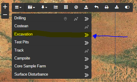
Click the polygon symbol on the right hand side then use single clicks to draw the excavation. To finish the drawing double click. A table will pop up requiring you to enter further information about the activity:
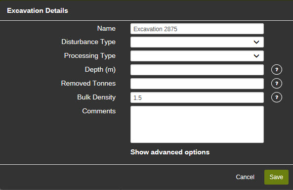
The following information needs to be entered before the drawing can be saved:
- Name: Enter a name for the excavation (a default name will be provided if nothing is entered).
- Disturbance Type: Select from the drop down menu – Scrape and Detect.
- Processing Type: Select from alluvial wet plant, dry blowing, none, other or small plant. Note: enter ‘none’ if processing is not required as this is a mandatory field.
- Depth (m): Enter the depth of the disturbance (metres) at the deepest point. Tonnage will be calculated from this. If you wish to change the tonnage the system has calculated see advanced options below,
- Removed tonnes: Refers to the number of tonnes that will be transported off tenure (rather than tonnes removed from the ground). Only enter a number here if you intend to transport tonnage off tenure. This is also known as bulk sampling.
- Bulk Density: Is the bulk density of the material. For example, if soil has a bulk density of 1.5, then 1 cubic metre of that sooil will weigh 1.5 tonnes.
Once all the required information has been entered, hit save and the drawing (including buffer) will appear on the map. You must click Save to save the details and the drawing. If invalid information is supplied, the field will be cleared. If the field is mandatory, the label will change to red.
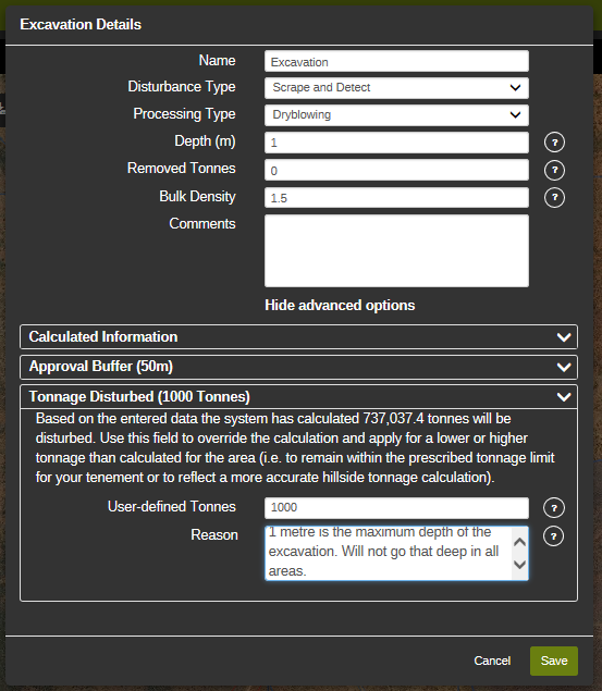
Advanced options
Click on show advanced options to display the additional information. Select hide advanced options to hide the additional information. Under advanced options for excavations you will find:
1. Calculated Information
2. Approval Buffer
3. Tonnage Disturbed
Calculated Information
The calculated information will display:
- Proposed Area Disturbed (hectares)
- Proposed Mass Disturbed (tonnes)
- MRF Rehabilitated Liability Estimate (RLE)
- MRF Estimated Levy
Approval Buffer
The default buffer for an excavation is set at 50 metres. You can request to increase this buffer, however please note that increasing the buffer may attract additional requests for information from the assessing officer.
Note: tonnage calculated based on the drawing and dimensions will appear in the advanced options section for your information once you have entered the dimensions.
Tonnage Disturbed
Based on the dimensions of the excavation the system will calculates a certain tonnage. Use this field to override the calculation and apply for a lower or higher tonnage than calculated for the area (i.e. to remain within the prescribed tonnage limit for your tenement or to reflect a more accurate hillside tonnage calculation).
A reason will need to be included as to why the tonnes have been overridden.