Create Point by Coordinate (Decimal degree format)
- Select the Create Point by Coordinate tool from the Enhanced Plotting Tools menu.
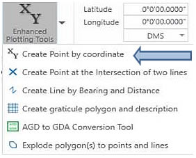
2. Select the Decimal Degrees (DD) option and then click ![]()
3. Manually enter a pair of coordinates in the format shown.
Lat: 22.016667
Long: 120.833338
4. Select a map scale.
Ensure the ![]() option is ticked on
option is ticked on
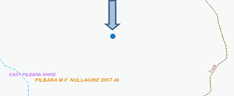
5. Click on the Zoom or Pan buttons to draw the new point on the map.
Within a few seconds a blue point is precisely plotted on the map.
Continue to enter as many coordinates as you want to.
Select ![]() if you wish to create a point in another format.
if you wish to create a point in another format.
Tip - your points plotted on the map can be snapped to when creating a polygon or using a measurement tool.
- Select the Create Point by Coordinate tool from the Enhanced Plotting Tools menu.
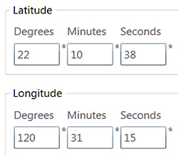
- Select the Degrees Minutes and Seconds (DMS) option and then click

- Manually enter a pair of coordinates in the format shown.
- Select a map scale.
Ensure the ![]() option is ticked on
option is ticked on
- Click on the Zoom or Pan buttons to draw the new point on the map.
Within a few seconds a blue point is accurately created on the map.
Continue to enter as many coordinates in this format as you want to.
Select ![]() if you wish to create a point in another format.
if you wish to create a point in another format.
- Select the Create Point by Coordinate tool from the Enhanced Plotting Tools menu.
- Select the Grid Coordinates option and then click
- Select the MGA Zone from the drop down menu.
- Manually enter a pair of MGA coordinates in the format shown.
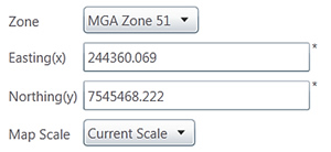
- Select a map scale from the options provided.
- Ensure the
 option is ticked on
 - Click on the Zoom or Pan buttons to draw the new point on the map.
- Within a few seconds a blue point is accurately created on the map.
- Continue to enter as many coordinates in this format as you want.
- Select
 if you wish to create a point in another format.
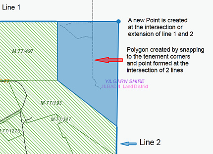
Creating a point at the intersection of two straight lines does not require the lines to actually intersect, however the projected alignment of the two lines must intersect within a reasonable distance.
- Create at least two lines on the Map.
You can use the standard create ![]() tool to draw two lines (Line 1 and 2) or by bearing and distance.
tool to draw two lines (Line 1 and 2) or by bearing and distance.
Hint: Hold the Ctrl key to snap to the tenement corners.
- From the Enhanced plotting Tools menu select Create a Point at the Intersection of Two Lines. You will need to select from the map two individual lines to intersect as shown below.
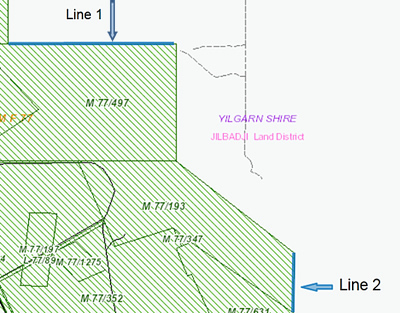
- With your mouse click on the 1st line. It will be highlighted in Yellow.
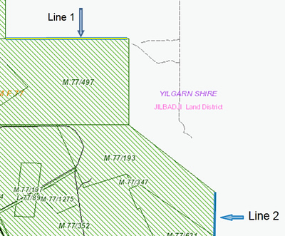
- Click .
- The system will prompt you to select the 2nd line.
- The system will automatically create a point at the intersection of the two lines selected as shown below.
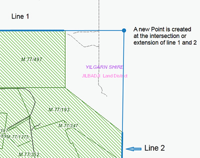
Tip - Use the create Polygon tool ![]() to construct a polygon. Hold Ctrl will allow you to snap to the tenement corners and the point created by the line extensions.
to construct a polygon. Hold Ctrl will allow you to snap to the tenement corners and the point created by the line extensions.