The following cases have been implemented.
TEN - 1: Unable to create a Form 21 containing a hole.
TEN - 4: Upload Coordinates - Add Spatial Reference in GDA94 Lat/Long.
TEN - 5: Upload Coordinates - Add MGA Zone 48 Spatial reference.
TEN - 6: TENGRAPH Web HTML5 (PUBLIC) link to WAMEX exploration reports is broken. (Chrome issue)
TEN - 8: Tenement Type Theme - TEN_TYPE attribute field display.
TEN - 15: Bookmarked Locations sensitivety menu issues.
TER - 1121: Additional Plotting Tools - Create Hole in Polygon, Clip Polygon.
TER - 1141: Printed Map text/arrow position issues.
FBTWAP - 4: Native Title Claim & Determination, Federal Court Number Attribute - spelling error.
The following enhancements were made.
TER - 551 Rain Forest Areas and ANCA Wetlands are no longer displayed on the map. Users are permitted to turn them on by selecting them from the Map Layers panel.
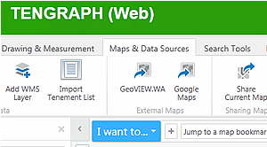
TER - 773 New hyperlinks for viewing the current location in GeoVIEW.WA HTML5
TER - 874 WA Heritage Sites are now shown on the map display by default between Scales 1 - 3,000,000.
The following enhancements were made.
12418 - Pop up message for TENGRAPH Web users.
13077 - New Layer - Historical Petroleum Title information.
The following enhancements and bug fixes were made.
12869 - Search by Holder or Colour by Holder with an Apostrophe does not work.
12965 - The TENGRAPH Web to WAMEX Link is not working.
12881 - Road Reserve GE number is removed from the Results.
12889 - Display survey feild book and project ID in TGW.
12940 - Remove the Combined Reporting Number from the Information window. (Use the Combined Reporting Number search tool).
12946 - View Tenement Holder - "Typo" in Continue button fixed.
10797 - Ability to run Internal Quick Appraisal Report for Special category Lands.
12877 - Ability to run Quick Appraisals for Historical FNAs and Section 19s.
12973 & 12667 - Removed fields fron exported .csv and shapefiles.
The following enhancements and bug fixes were made.
12740 - Opening WA map display updated.
12730 - Help Link from TGW to "Safety First" web page.
12739 - Help Link from TGW to "Where Can I Go Prospecting" web page.
12707 - Commonwealth Petroleum Title Holder Details.
12703 - Minor attribute display changes affecting Land Divisions, Suburban and Estate Areas.
12763 - A3 Portrait Map not printing Landgate Aerial Imagery fixed.
12768 - Date of Landgate Areial Imagery provided.
12777 - Form 21 Attachment 1. Exploration licence spelling and date fixes.
12800 - Aboriginal Communities layer updated.
12790 - Commonwealth Heritage Listings - Attribute Change.
12791 - NAtional Heritage Listing Layer - Attribute Change. URL link to the Department of Environment and energy has been added.
12827 - Quick Apprasial Enhancement - Certificate of Title with the Plan on Lot number is now shown with any affected freehold land. (Remember to untick the summerise button Private/Freehold Land checkbox before running the quick apprasial).
12816, 12814, 12850 - Minor Quick Appraisal formatting and bug fixes.
The following enhancements and bug fixes were made.
12683 - The Townsite Layer updated to include LGA Townsites.
12664 - External users can now save their constructed Drawings as a shapefile.

12644 - Shapefiles exported from TGW are now recognised by ArcMap with the GD94 datum.
12629 - DMP Data Centre icon changed to DMIRS

12643 - The Search by Graticule, Form21 Attachment workflow error fixed.
12595 - Colour by tenement holder workflow error fixed by a workaround received from Geocortex.
12145 - TGW email updated with new Department name.
The following enhancements and bug fixes were made:
12602 - External users are unable to print Landgate Aerial Imagery on their maps - Issue fixed in this version.
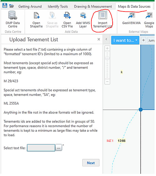
12575 - External user request. The number of tenements uploaded from a Text file into the Results List increased from 100 to 1,000.
System Improvement for TENGRAPH Web Release 1.0.6 - 30 January 2018
MAJOR Performance bug fix:
Tenement searches should now be finishing and displaying on the map quicker.
The following enhancements were made:
12511 - Application configuration settings changed to address workflow performance issues. (In particular the Tenement Search and Enquiry)
12232 - A new hard coded URL link to open the Description of Land Types PDF Document implemented.
12485 - GDA94 Graticules selected from the map display can be exported and saved as a Shapefile.
12501 - The TENGRAPH Aerial Imagery link changed to a new Landgate Imagery service. (Note the ne new Landgate / SLIP watermark displayed on the map.)
12486 - A new "Drawing and Measurement" tool that explodes polygon drawings into points and lines has been implemented.
12512 - References of all 'Proposed 5 G' reserves changed to display as 'Proposed 5 H reserves'
12529 - The accuracy of the Combined Reporting Number Search has been improved by getting the results directly from WAMEX instead of the SDI database.
System Improvement for TENGRAPH Web Release 1.0.5 - 01 December 2017
The following issues have been resolved:
12268 - The Southwest Native Title Settlement layer display fixed.
12286 - Aboriginal Heritage Areas - Gazetted, the map layer properties modified to make more visible.
12287 - New Display and Label properties affecting Commonwealth and World Heritage Layers.
12360 - Export to Google Earth (KML File name changes)
12359 - A new Electricity Transmission lines layer.
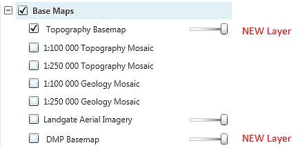
11658 - New independent Transparency Slide bars for the Topography and Geology Map Mosaics.
12145 - The "Description of Land Types in TENGRAPH" PDF document has been revised.
12406 - TGW Problem importing CSV files with Zone 50 grid coordinates fixed.
12419 - Saving Projects 'Share with everyone' default setting changed to unchecked
12457 - Tenement text file upload limit increased from 50 to 100.
12461 - Create point by MGA map coordinates bug fix.
Emits related
12130 - Any affected Threatened Ecological Communities will be summarised in the Quick Appraisal Report with the next emits release.
System Improvement for TENGRAPH Web Release 1.0.4 - 09 October 2017
- The WA coastline and lakes on the Topographic base map display updated.
- Topography and Geological Map Mosaics Metadata links updated.
- The "Help & Feedback" Acknowledgements document updated.
- The "Share Current Map" Tool added to the "I want to..." drop down menu.
11480 - Improved pixel tolerance for identifying point features on the map display using the "What's here" facility
11578 - The standard tenement status legend removed from maps generated in the Tenement Type & Survey Map layer theme.
11801 - Ability to print maps (& Print object details) over Cocos (Keeling) Island Zone and Commonwealth Petroleum titles. (Zone47) implemented.
12169 - Water (Unallocated Crown Land) Cadastre Layer added.
12223 - Road Network and Rivers (Major and minor watercourses) removed from Land Map service. (Now displayed in Topography Base map)
12122 - Amalgamation Quick Appraisals - Now includes the EL tenement Id in the report.
12192 - Pastoral LEASE HOLDER removed from the information display.
12196 - Attribute Display window enhancements.
12226 - Quick Appraisal Service "Unavailable" error message updated to give a better indication as to the cause of the error.
12239 - The TENGRAPH Web Getting Started Guide updated with the new DMIRS department name.
12265 - Raster Map print enhancements.
12242 - A1 Vector Map Legend Layer Name Enhancement.
12283 - Users can now search Land Act Lot by CT & PIPARCEL. Attribute Display also updated with CT & PIPARCEL details.
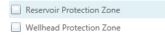
12284 - Wellhead Protection & Reservoir Protection Zones - display enhancement.
12297 - The Search Tenement Holder workflow improved. (Search changed to use POST instead of GET for the map service query.
12148 - New Quick Appraisal option to Select Native Title Determination Outcomes (internal users only)
- Section 19 Formatted Land Id shown in the label.
- 3 Nautical Mile Layer update
Quick Appraisal Enhancements implemented 21st Sept. 2017
11895 - Quick Appraisal Results now show the Section 19 Land Id.
11896 - The ILUA Subject Matter is now included in the Quick Appraisal Results.
12248 - TENGRAPH Web - Quick Appraisal report has been enhanced to show any intersections with Offshore Areas in Ha.
12249 - Better Appraisal area calculations for small overlaps. - Spheroidal Calculations bug fix.
12179 - Dead tenements are now sorted by their Tenement ID: in the Quick Appraisal Report
12264 - Quick Appraisal changes for the new Water (Unallocated Crown Land) Layer
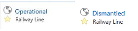
12269 - The Railway line status (Dismantled or Operational) is now shown in the Quick Appraisal results
11925 - Quick Appraisal Report now shows The Crown or Pastoral lease Quick Appraisal ID shown in the header. (Only affects Internal users)
12233 - Intersections with EPA Assessment Areas have been removed from the Quick Appraisal Report (Only affects internal users).
System Improvement for TENGRAPH Web Release 1.0.3 - 27 July 2017
- Updated with the new Department branding on all prints and reports reflecting the Machinery of Government (MOG) changes.
- Allows users to copy imported shapefiles to a drawing
- This version also fixes the Search by Place Name/Gazetteer bug.
System Improvement for TENGRAPH Web Release 1.0.2 - 14 July 2017
Major enhancements
- Performance improvements.
The increased TENGRAPH Web usage (344 users in June) has enabled our IT people to analyse the system performance for bottlenecks. As a result access to the Topography base map has changed and now redraws faster. The Cadastre layer group now has its own map service which improves the land refresh rate. Security checks have also been rationalised improving the overall performance.
- New Cadastre Map Service
The Cadastre layers have been taken out of the Land map service into their own map service.
These changes have been implemented for better performance and provide the cadastre layers with an independent transparency slide bar.
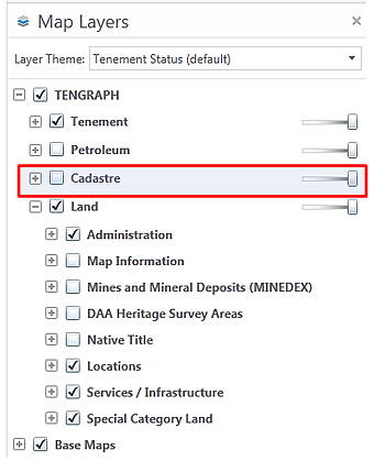
Note: Cadastre will not display on your map unless the check box is ticked. ![]()
Other enhancements
12086: The brackets have been removed from the main header

12093: Tenement History boundary insert date display changed to another field
12032: New enhancements to the Create Line by bearing and distance tool
12018: Minor enhancements and user tips to the Quick Appraisal Constructed Object/shapefile tools
12109: The Standard Survey Mark (SSM) information window display is now attributed
11406: Petroleum title search enhancements and user tips.
12119: The Railway Line status is shown in the results when selected on the map.
System Improvement for TENGRAPH Web Release 1.0.1 - 08 May 2017
Major Enhancements
- New Help system with training videos.
Click here to access TENGRAPH Web Training Videos
The FAQ, Drawing Tools and Quick Reference Help are now linked to the Department’s Open Text Website Management (WSM) system
- A New Google Maps link has been implemented. Clicking on the icon as shown below will open Google Maps with the same extent as your current TENGRAPH Web map display.
Minor Enhancements
Case No 12017 - All A1 plots are now emailed to user. (Public users can still download A1 plots from front counter Kiosks.)
Case No 12006 - Search for Historical Maps typo mistake fixed
Case No 11998 - The number of Attributes exported from Recent activity results has been reduced.
Case No 11981 - An Abandoned mines inventory link to MINEDEX implemented
Case No 11368 - A Petroleum wells link to WAPIMS implemented.
Case No 11952 - Help pages, Terms of Use - Disclaimer
Case No 12002 - The "Open Google Street View Here" option from the "Context" map display menu doesn't work due to licencing issues and has been removed.
System Improvements for TENGRAPH Web Release 03 April 2017
Enhancements
New Base Maps
- A new cached Topography base map displaying the road network, rivers and coastline (Default display) has been implemented improving the map redrawing speed.
- An option to overlay the DMP (GeoVIEW.WA) Basemap.
User Tips
- More user tips placed throughout the application.
Other TENGRAPH Web enhancements and bug fixes:
Case No 11921 - Tenement Survey field name changed from SURVEYED to SURVEY STATUS
Case No 11845 - Constructed Graticule Blocks Missing (bug) from some Map Prints fixed.
Case No 11828 - Recent Activity search options changed to work on individual activity types.
Case No 11829 - Allows users to run a Quick Appraisal Report affecting an open Shapefile drawn on the map.
Case No 11831 - Allows users to extract mining tenement selections as a CSV file
Case No 11829 - Fixes the missing asterisk from surveyed inspection tenements labels e.g. (M 45/57 and M 45/284)
Case No 11867 - The map scale bar prints in a better position
Case No 11833 - The GE number has been removed from exported dbf and csv files
The "State Agreement Act Area" map layer has been removed as it does not contain any information.
System Improvements for TENGRAPH Web Release 19 January 2017
The following issues have been resolved:
Case No 11806 - Graticule polygons can be selected to run Quick Appraisal Reports
Case No 11776 - The Copy to Drawing tool has been fixed to work on all TENGRAPH layers
Case No 11801 - Maps can now be printed over Christmas and other offshore islands located in Zones 48 & 49. (Bug fix)
Case No 11782 - Information Panel Results reflect the correct road network displayed on the map.
Mountains, Lakes etc. selected on the map display are correctly listed in the results panel.
Case No 11341 - The 8:30am Release time display affecting exploration licences has been fixed.
Case No 11781 - Raster prints now include base maps (Bug fixed)
Case No 11789 - The Insert Date Stamps affecting Pending Amalgamations and Restorations are no longer visible.
Case No 11790 - All Holders Field name has been added to the attribute display window affecting Petroleum Titles.
Case No 11798 - Dead superseded surveyed tenements are now printed on Vector generated maps. (Bug fixed)
Case No 11754 - Some Quick Appraisal results incorrectly show an encroachment greater than 100%. (fixed in next emits release)
Case No 11694 - Quick Appraisal of Freehold Land bug fix. (Freehold Land must be selected from the results for it to run.)
System Improvements for TENGRAPH Web Release 09 December 2016
Enhancement
- Reservoir and Wellhead Protection Zones map layers have been added.
The following issues have been resolved:
Case No 11684 - A Getting Started Guide is available from the “Help & Feedback†Tab
Case No 11687 - The Quick Reference Manual has been updated
Case No 11750 - The Surface Water and Ground Water Results panel display have been improved.
Case No 10997 - Base maps have a metadata statement included
Case No 11365 - Results panel - an option to view Historical WAMEX tenement boundaries.
Case No 11394 - Public users allowed to Print Object Details directly (Instead of emailing them)
Case No 11147 - Extract Tenement Drawings created in the Survey Theme
Case No 11731 - Quick Appraisal Improvement
Case No 11750 - SWA GWA Results Display
Case No 11696 - Quick Appraisal report - multiple holder issue
Case No 11721 - Tengraph Web Appraisal crashes on FNA 13090 and other similarly located FNA's.
Case No 11676 - Quick Appraisal Lease changes
Case No 11685 - Quick Appraisal - Surface Water Area
Case No 11686 - Quick Appraisal - Aboriginal Heritage Results
Case No 11757 - Quick Appraisal Improvement
Case No 11763 - QA ordering of results fix
Case No 11503 - Public Tenement History View - description bug fix
Case No 11743 - "Departmental Use Only" text removed from Kiosk Print Object reports.
Case No 11693 - The map generated with the Quick Appraisal Report has been upgraded.
Case No 11397 - Gateway time out issues affecting the Quick Appraisal Interactive Map have been improved.
Case No 11413 - Users restricted from exporting Non Departmental data in a shape or CSV file format.
Case No 11695 - Intuitive text added to the search by a graticule workflow.
Case No 11669 - GDA94 Graticule results display has been fixed
Case No 11678 - Users can now snap to GDA94 graticules by default.
Case No 11638 - A1 Landscape Maps now printing with legend
Case No 11674 - Change 250k Topography to 250K Topography in the Legend
Case No 11021 - The Scale Bar Length shown on TGW Map Prints has been improved
Case No 11651 - Help / tips text added to the Recent Activity Search facility more user friendly.
Case No 11646 - Recent activity - date entered by users changed so it can only be in the past.
Case No 11589 - The tenement register link has been fixed for kiosk users.
Case No 11345 - Links to Help Files have been fixed for external users.
Case No 11518 - The TENGRAPH Web "Maps & Data Sources" links to GeoVIEW (Geology and WAMEX) have been upgraded.
Case No 11599 - Perth Urban Area - Results Display Improved
Case No 11557 - Extra map scales options have been added when printing a map.