Save and Open Project
Save Project
If you have added measurements, markup, or layers to a map, you can save a map as a project, and then share it with others or continue to work on it later. You can save a project to the server or as file to your computer. When you save a project to the server, the application creates a URL that you can send to others. When they paste the URL into a browser, it opens your project and they can see your map.
Open Project
Once you have saved a project, you open it again by clicking Open Project (on the server) or Open Project File (on your computer).
![]()
![]() Click here to open your saved project
Click here to open your saved project
Click here to save your drawings and layer configuration as a project
Tab 2 - Identify Tools
Identify Tools
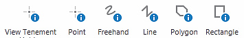
Click any location on the map using one of the Identify tools.
Tengraph features/objects affected are displayed in the Results List
Identified Area to Markup

Adds the Identified Area to the Markup layer as a drawing.
View Tenement Holder

Click on any mining tenement displayed on the map. The current holder is shown in the Results.
Clear Screen
![]()
Will restart TENGRAPH deleting the browser history and any drawings created during your session.
(Useful for prospectors accessing TENGRAPH on PCs located in public areas.)
Tab 3 - Drawing & Measurement
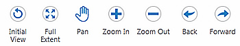
Standard Drawing Tools
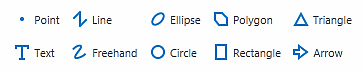
TIP - When drawing hold down the "Ctrl" key to snap to tenement corners or other snap able objects visible on the map.
Standard Editing Tools
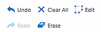
TIP - Use the Edit tool to change the colour of your drawing.
Enhanced Plotting Tools
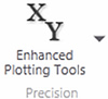
Refer to Enhanced TENGRAPH Web Plotting Tools for further information.
Measurement Tools
Distance
![]()
Measures a distance on the map.
Area

Measures both distance and area on the map
Tip - To add the measurement as a drawing to the map, click the "Add as Drawing tool" either during or after you use the Measurement tools.
Snapping Coordinates
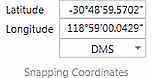
Coordinates display of a snapped point or vertex.
Refer to Measure Distance and Area for further information.
Tab 4 - Maps & Data Sources
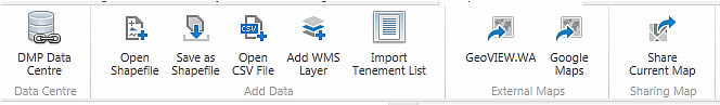
Link to DMP Data Centre

Opens the Data and Software Centre where DMP spatial datasets and software (including mining tenement files) are available for download.
Save as Shapefile

Save / Export shapefiles or CSV files.
Add WMS Layer

Adds a geo referenced Web Mapping Service.
Open GeoVIEW

View the current location in the GeoVIEW.WA system.
Open Shapefile

Adds an Esri shapefile to the map.
Open CSV File

Adds a CSV file containing spatial coordinates to the map
Import Tenement List

Import a text file containing Tenement ID's to the Results List.
Open Google Maps

View the current location in Google Maps / Street view.
Share Current Map

Allows another person to remotely open and view the same map extent as yours.

Tenement Search

Enquire by live or dead mining tenements.
Petroleum

Run an enquiry on petroleum title layers.
Map Sheet

Enquire by Mapsheet name or number.
Zoom to Coordinate

Zooms to and plots a specified Latitude/Longitude or MGA map coordinate entered by the user.
Gazetteer / Place Name

Enquire by a locality stored in the gazetteer database supplied by Landgate
Mine Site

Enquire on MINEDEX mine and mineral deposits.
Zoom to Graticule
![]()
Enquire by graticule blocks.
 Advanced Tenement Search Tools
Clicking on the Advanced Tenement icon will open the drop down menu with these specialised tools...
Tenement Holder

Enquire on a tenement holder’s name to find a tenement.
Recent Activity

Displays new tenement applications, grants, deaths and partial surrenders.
Dead Tenement Search

Enquire by Tenement type, death reason and year cancelled.
Historical Tenement Maps

Search, view and download scanned historical tenement (Pre-TENGRAPH) maps in PDF format..
Colour Tenements by Holder

A tool that colours tenements by company or individual holder name.
Tenement Release

Enquire on exploration licences affected by recent compulsory partial surrenders.
Combined Reporting Number

Enquire by combined reporting number to find tenements.
 Advanced Land Search Tools
Clicking on the Advanced Land icon will open the drop down menu with these specialised tools...
Land Act
![]()
Enquire on freehold land by lot number or certificate of title.
Pastoral Lease
![]()
Enquire by pastoral lease name.
Section 19
![]()
Enquire by Section 19.
Native Title Determination
![]()
Enquire by Native Tile Determination.
Reserve
![]()
Conducts a search through reserve layers.
File Notation Area
![]()
Enquire by File Notation number.
Native Title Claim
![]()
Enquire by Native Title Claim.
ILUA Area
![]()
Enquire by Indigenous Land Use Agreement (ILUA) Area.
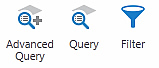 Refine Data Tools
Simple Query Builder

The Query Builder tool makes it possible to build your own queries.
Advanced Filter Builder

Use the Advanced Filter Builder tool to exclude data that you are not interested in on a particular layer.
Advanced Query Builder

The Advanced Query Builder tool makes it possible to build or type in advanced SQL statements.
Tab 6 - Printing & Reports
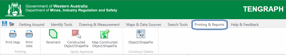

Print Jobs
![]()
Shows the status of your print jobs.
Print Polygon Details
Print the spatial coordinates of your own constructed polygon or drawing.(Print object details)
Tenement Quick Appraisal Report

The quick appraisal report lists land and services overlaying a mining tenement
Constructed Object/Shapefile
Quick Appraisal Report

The quick appraisal report lists land and services overlaying a constructed polygon or shapefile.
Map Constructed Object/Shapefile
Quick Appraisal Interactive Map

Opens the quick appraisal interactive map
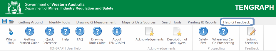
Tab 7 - Help & Feedback
The Help & Feedback Tab contains links to help documents, guides to prospecting and email support from the TENGRAPH team.
What's This?

Opens a specific topic in the Geocortex Help Guide relevant to the location selected with your mouse.
TENGRAPH Quick Reference Manual

Overview of the TENGRAPH Web Tools and display options.
FAQ
![]()
Opens the Frequently Asked Questions.
About TENGRAPH

Shows the TENGRAPH software version and database environment details.
Description of Land Layers

Description of land type categories sourced from other agencies.
Getting Started Guide

TENGRAPH Web Beginners Guide. Opens the Getting Started Guide
Help

Opens the Welcome page within the detailed Geocortex (Silverlight) Help Guide. Guide
Drawing Tools Guide

Explains how to plot points, lines and polygons.
Acknowledgements
Acknowledgement of land layers sourced from other agencies.
Submit Feedback

Email TENGRAPH feedback or inquires to support staff.
Safety First

Provides important safety advice while prospecting in remote areas of the State.
Where you Can go Prospecting

Provides information on land available for prospecting and permissions required.