The Capricorn Orogen Passive Array (COPA) is a network of more than 60 broadband seismic stations deployed from 2014 to 2017 in an area covering the Capricorn Orogen. This area extends from the southern Pilbara Craton to the northern Yilgarn Craton. The network records continuous data, with the aim of imaging large-scale tectonic structures through ambient noise tomography, receiver function studies and shear-wave splitting.
This project was carried out as part of the ‘Distal Footprints of Giant Ore Systems: Capricorn Case Study’, a multidisciplinary investigation into the large- and small-scale features of the Capricorn Orogen of Western Australia. The project was funded by the Geological Survey of Western Australia (GSWA), the Science and Industry Endowment Fund (SIEF) and the Core to Crust Fluid Systems Centre of Excellence (CCFS), which provided a salary for a principle investigator.
The project focused on the crustal and lithospheric structure of the Capricorn Orogen including the Gascoyne Province and the flanking Archean cratons of the Yilgarn and Pilbara. This is an area which has received little attention in spite of several gold deposits such as Plutonic, Degrussa, Abra, Paulsens and recognised mineral systems for other commodities (e.g. Fe, Cu, Zn, U and Pb). It has a complex geological evolution which is largely hidden under regolith cover. The Distal Footprints project aimed to integrate regional- and lithospheric-scale datasets with prospect-scale studies to determine and develop scale-dependent criteria for the recognition of the footprint of an ore system.
The relatively small size of most mineral deposits presents a major mineral exploration problem. However, mineral deposits are now being recognised as just a small part of a much larger entity — a mineral system — which encompasses the entire lithospheric pathway of mineralisation in space and time, from fluid and metal sources and energy drivers, through the sites of mineral deposition, to the exit of depleted flux. The generation of a mineral system is in turn coupled to geodynamic setting and larger scale tectonic drivers that place fundamental controls on Earth system processes. The key to the discovery of new Australian resources is the ability to understand mineral deposits within the context of evolving, lithospheric-scale architecture, history and processes.
The aim of the Passive Seismic part of the Distal Footprints project is to image the large-scale geometry and lithospheric architecture by means of passive seismological and magnetotelluric methods with the further aim of deducing the tectonic evolution of the region, and in so doing, assist mineral explorers in locating medium to small-sized mineral deposits.
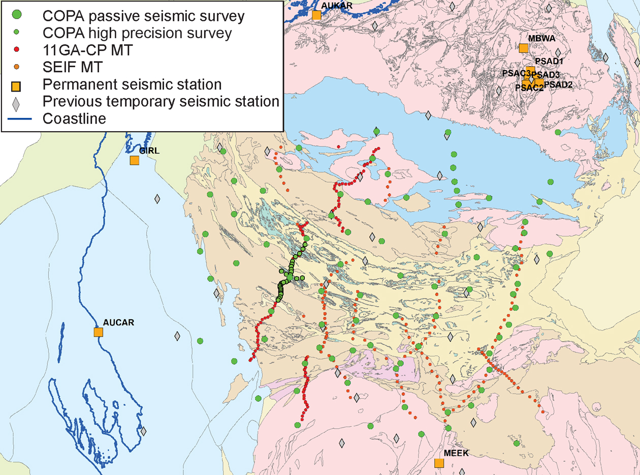
The initial network was established in March 2014 and the final seismometers were removed in September 2018. Over that four years, 3 terabytes of data were recorded over a total of 83 temporary stations with an overall 70% recovery of data.
The initial network was composed of two parts: a ‘permanent framework’ of nine stations and a mobile network of up to 24 stations (see figure). The network started in the west and was progressively migrated eastwards until the easternmost stations lay along the Great Northern Highway. All stations were three-component broadband seismometers which were downloaded on a regular basis.
A subarray of 25 Trillium Compact 120-s seismometers and ANU recorders was deployed for a period of 12 months within the timeframe of the larger array. This was known as the High Precision Survey (HPS) and was designed to image by passive seismic techniques, a section of the 10GA-CP2 deep seismic reflection line for comparison of results by passive and active images.
Data processing included receiver function analysis for depth to Moho, bulk crustal composition and common conversion point imaging, ambient noise tomography and body wave tomography to look at the subcontinental lithospheric mantle.
Reports on this project are being compiled and will be available through the DMIRS eBookshop.
Contact
For more information contact:
seismology@dmirs.wa.gov.au