The project is using information acquired from the Kidson Deep Crustal Seismic Reflection Survey in 2018.
| Date: | Tuesday, 10 September 2019 |
|---|
The Geological Survey of Western Australia (GSWA) in partnership with Geoscience Australia, funded under the Exploring for the Future program, has begun drilling on a deep stratigraphic well in the South West Canning Basin.
The project is investigating the geology within the Waukarlycarly Embayment, a fault-bound depression in ancient igneous and metamorphic rocks that has subsequently filled with a sequence of younger sedimentary rocks.
Using information acquired from the Kidson Deep Crustal Seismic Reflection Survey in 2018, preparation work for the stratigraphic drilling program began in July and the project is expected to finish in November 2019.
GSWA, a part of the Department of Mines, Industry Regulation and Safety (DMIRS), is managing the the Waukarlycarly 1 stratigraphic drilling program.
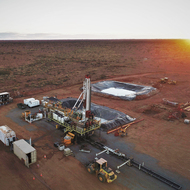
DMIRS Executive Director Geological Survey and Resource Strategy Jeff Haworth said the drilling is being carried out on an existing cleared area next to the Marble Bar-Telfer Road, about 67km west of Telfer.
“Drilling began on 1 September and the well is planned to reach a total depth of around 2,200m,” he said.
“It will provide a much better understanding of the little-known subsurface geology of this region and will also provide a test of geological interpretations made from the Kidson survey.”
This well is designed to fill a major data gap in the knowledge of the southern Canning Basin.
The Waukarlycarly Embayment is currently defined only from geophysical data (seismic and gravity), and has not previously been evaluated by deep drilling beyond about 200m.
The project’s objectives are to:
- acquire a fully cored stratigraphic section through the Waukarlycarly Embayment including the top of the basement it overlies;
- acquire a suite of wireline logs through the same section;
- determine the ages of stratigraphic units and assign to established Canning Basin stratigraphy;
- assist in the interpretation of the Kidson Seismic Survey; and
- evaluate the hydrocarbon, mineral and hydrogeological potential of the Waukarlycarly Embayment.
Mr Haworth said results will be made publically available in mid-2020.
Further information about the department’s geoscientific projects is available at: www.dmirs.wa.gov.au/gswa
Information about the Exploring for the Future program is available at: www.ga.gov.au/eftf