Earthquake recording research
| Date: | Tuesday, 14 November 2017 |
|---|
A major international scientific collaboration that will monitor earthquake vibrations from around the globe has started in Australia’s northwest.
The scientists believe their work will yield valuable geological data about the deep structure of the region, including parts of the vast Canning Basin.
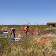
The first stage of the project began in early September with the installation of 20 vibration monitoring instruments between Port Hedland and the Kimberley plateau. A second stage to install an additional 40 seismometers to achieve higher data resolution is planned for 2018.
Experts from the Department of Mines, Industry Regulation and Safety (DMIRS), the Chinese Academy of Sciences (Academy), Macquarie University and the University of Western Australia are involved in the project through the Australian Research Council Centre of Excellence for Core to Crust Fluid Systems (CCFS).
DMIRS Manager 3D Geoscience Klaus Gessner said Macquarie University was the lead institution and that its Research Associate Dr Huaiyu Yuan had been seconded to work with GSWA on the earthquake monitoring project.
“Representatives from the Academy, an International Partner in the CCFS, participated in setting up and will be involved in monitoring the seismometers,” Dr Gessner said.
“The Academy has also provided the equipment for the monitoring project, while we have been able to provide the local expertise.
“The department’s Kimberley Liaison Officer Brian Lloyd has been invaluable in working with local stakeholders to assist us in installing the monitors on suitable sites throughout the region.
Dr Gessner said the Academy is interested in the data as part of its geoscience research because no-one has ever undertaken a passive seismic survey on this scale in northwest Australia, so the results will be a significant addition to global scientific knowledge.
“And for GSWA, the data will help to deduce the structure of the ground beneath us to depths of around 50km to 100km, and show how the different blocks of the Western Australian part of the continent fit together,” Dr Gessner said.
The selected sites were already in use, such as at roadhouses or at pastoral homesteads, and did not require any new disturbance of land. Scientists will visit the sites every three to four months for data download and servicing.