Forthcoming geophysical data releases
Thursday 20 February after 0900 AWST (UTC +8)
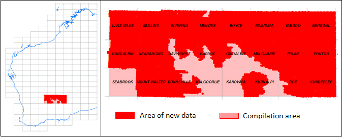
Goldfields 2013 gravity survey — final data
Final data from the regional ground gravity survey completed in December 2013 will be available from the GSWA website on Latest Geophysical Surveys. A total of 8115 new gravity observations were made on a 2.5 km grid. The release will include grids and images of a compilation of the new data merged with earlier data. Point-located (‘vector’) data and grids can be downloaded free of charge from the Geophysical Archive Data Delivery System (GADDS) or purchased on disk from Geoscience Australia.
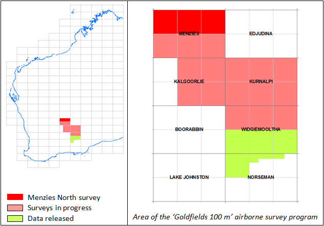
Menzies North 2013 airborne magnetic and radiometric survey — preliminary data
Images and grids of preliminary data from the regional magnetic and radiometric survey at line spacing of 100 m completed in November 2013 will be available from the GSWA website on Latest Geophysical Surveys.
Note: This release will be upgraded to final data if these are available by this date.
Most recent geophysical data releases
| Date | Survey | Data status |
| 25 Oct 2013 | WA 1:250 000 map sheets geophysical images and grids | 2013 – v1 |
| 24 Oct 2013 | Esperance 2013 gravity survey | Final |
| 20 Sep 2013 | Radiometric anomaly grids (80 m) of WA | 2013 – v1 |
| 20 Jun 2013 | Magnetic anomaly grid (40 m) of WA | 2013 – v1 |
| 20 Jun 2013 | Magnetic anomaly grid (80 m) of WA | 2013 – v2 |
| 06 Jun 2013 | Widgiemooltha South 2012 airborne mag/rad survey | Final |
Access to previously released geophysical data
Image data from previous geophysical releases can be found on our Regional Geophysical Surveys page. Digital located and grid data can be purchased on media from Geoscience Australia
Spotlight on a product — new Shark Bay bulletin released
by PE Playford, AE Cockbain, BF Berry, AP Roberts, PW Haines, and BP Brooke
 Strange and ancient underwater life forms, an unsolved shipwreck mystery and the record left by mega-tsunamis that struck millennia ago are a few of the fascinating ingredients in a new book launched on 5 February 2014 by the Minister for Mines and Petroleum, Bill Marmion.
The Geology of Shark Bay is a labour of love and the culmination of about 50 years’ research by Geological Survey of Western Australia (GSWA) geologist and author Dr Phil Playford and a team of co-authors.
Speaking to invited guests during the launch at Mineral House, Mr Marmion said the book would be of worldwide interest, not only to geologists and other scientists, but also to members of the public.
Shark Bay’s living stromatolites featured in the book closely resemble the earth’s earliest life forms found billions of years ago during the pre-Cambrian period. They are renowned as the most extensive and diverse organisms of their kind found anywhere on earth. They were first discovered by Dr Playford in 1954 and were largely responsible for Shark Bay being listed as a World Heritage Area.
 ‘Also of major importance is the existence at Shark Bay, Barrow Island, Legendre Island, and along the Kimberley coast, of deposits formed by mega-tsunamis that struck the coast up to 5000 years ago,’ Mr Marmion said. They are among the largest tsunami deposits known anywhere on earth.
The Zuytdorp Cliffs form another striking feature of the geology of the area.
This precipitous line of cliffs — some 200 km long and up to 250 m high between Shark Bay and Kalbarri — is named after the Dutch East India Company’s ship Zuytdorp, which was wrecked at their feet in 1712.
‘Survivors were some of the first European inhabitants of Australia,’ Mr Marmion said.
DID YOU KNOW?
- The Zuytdorp was the first Dutch wreck to be found and identified on the Australian coast and Dr Playford was formally recognized by the State Government in 1996 as being a co-discoverer.
- Another aspect of the fascinating human history of the Shark Bay area covered in the book is the 1616 visit by explorer Dirk Hartog in the Dutch East India Company’s ship the Eendracht.
- The 400th anniversary of Dirk Hartog’s landing will be celebrated in 2016.
About the author
Dr Phil Playford was born in Western Australia and was awarded BSc (Hons) and honorary DSc degrees by The University of Western Australia, and a PhD by Stanford University, which he attended with Fulbright and Hackett Scholarships. He has worked for the Western Australian and Federal Governments, and the petroleum-exploration industry, is a former Director of the Geological Survey of Western Australia (GSWA) and a former Assistant Director-General of Mines. His principal geological research interests have been in the Canning Basin (on Devonian reefs), Shark Bay, and the Perth Basin. During his long career, Phil has received many prestigious honours from academia and industry, and is a Member of the Order of Australia (AM). He is currently an Honorary Associate of GSWA and the Western Australian Museum.
How to purchase
The book is available to purchase from <www.dmp.wa.gov.au/GSWApublications> at a cost of $70 (including GST). It is also available as a free downloadable PDF.
GSWA Open Day 2014
 This is a great opportunity to hear presentations on the latest results from GSWA's geoscience programs, including collaborative research with CSIRO and the Centre for Exploration Targeting (CET).
Activities and results of the Exploration Incentive Scheme (EIS) will be outlined including the launch of Round 9 of the Government Co-funded Exploration Drilling program.
Throughout the day there will be geological presentations, an extensive poster display, and demonstrations of online systems including the new WAMEX and the drillhole database.
Event details
Date: Friday 21 February 2014
Time: 8:15 am – 4:30 pm
Venue: The Esplanade Hotel, Fremantle
Cost: $110
Contact details
Phone: +61 8 9222 3168
Fax: +61 8 9222 3633
Email: nell.stoyanoff@dmp.wa.gov.au
Download a copy of the GSWA 2014 Open Day program.
Additional information
Register here. For any queries, please contact Sue McLennan, Stars Event Management, on email sue.mclennan@starsevents.com.au or Tel: 0409 370 749.
Co-funded Drilling Round 9 to be launched at GSWA Open Day
 The Minister for Mines will launch the next round of the Exploration Incentive Scheme (EIS) Co-funded Drilling Program at the GSWA Open Day on Friday 21 February.
The online system for applications for co-funding of drilling projects to be undertaken in the financial year 2014–15, will be open from 21 February and remain open until 5 pm (WST) on 28 March.
More information will be available at www.dmp.wa.gov.au/eisdrilling or from Margaret Ellis, Co-ordinator EIS, margaret.ellis@dmp.wa.gov.au,
Tel (08) 9222 3509.
Albany–Fraser Orogen deep crustal seismic reflection survey
Release of the Albany–Fraser Orogen Deep Crustal Seismic Reflection Survey preliminary migrated seismic line cross sections
(Survey L201, Albany–Fraser Orogen 2012)

 The Albany–Fraser deep crustal seismic reflection survey was conducted across the southeastern margin of the Yilgarn Craton and the adjacent Albany–Fraser Orogen during April to June 2012, funded through the Western Australian Government's Royalties for Regions Exploration Incentive Scheme (EIS). Acquisition and processing has been managed by Geoscience Australia (GA) through the National Collaboration Framework. This activity, adding to a network of existing deep seismic traverses, improves the understanding of the crustal structure of Western Australia.
The objectives the Albany–Fraser Orogen seismic reflection survey was to:
- image the crustal architecture of the Yilgarn Craton margin and its relationship to the Albany–Fraser Orogen
- establish the subsurface extent of the Yilgarn Craton beneath the Albany–Fraser Orogen, and look for mantle-tapping structures that may have provided fluid pathways for mineralization
- design the seismic lines to cross several major faults, such as the Cundeelee Fault, the Fraser Fault, the Newman Shear Zone, the Red Island Shear Zone and the Rodona Shear Zone
- examine the deep crustal structure of the Albany–Fraser Orogen and investigate the processes that drove Paleoproterozoic rifting and magmatism along the craton margin, and Mesoproterozoic tectonic assembly
- test models of Mesoproterozoic fold and thrust belt architecture in the Albany–Fraser Orogen
- examine primary and structural relationships between tectonic units mapped at the surface.
The data to be released comprises the preliminary migrated seismic line cross sections of lines 12GA–AF1, 12GA–AF2 and 12GA–AF3 together with the seismic shot points and the common depth points (CDP) shown on the cross section images.
In 2013–14 deep crustal reflection seismic survey acquisition under EIS has continued with the completion of the Eucla–Gawler survey in collaboration with GA, Geological Survey of South Australia and AuScope. This line continued east from Haig at the end of 12GA–AF3 to Tarcoola in South Australia. GSWA is also planning an EIS-funded line across the Canning Basin linking the Pilbara and the Kimberley to be acquired in May and June 2014.
Database training — new dates for 2014 announced

The Geological Survey of Western Australia (GSWA) offers FREE training in its databases and online systems. The training is in the form of a presentation with hands on interaction in most systems. Topics include:
- navigating the Department of Mines and Petroleum's (DMP) website
- searching for geoscience publications
- finding digital datasets using the Data and Software Centre
- searching for open-file mineral exploration reports using WAMEX
- searching the mineral drillholes and geochemistry databases
- bringing it all together with the interactive map viewer, GeoVIEW.WA and GeoMap.WA, a standalone GIS viewer for Windows.
The morning session will be a basic introduction of how to use all the programs. During the afternoon session, participants will be able to get more in-depth practice using the programs with their own examples, and get some one-on-one advice about individual issues. A hands-on demonstration of the MRT software for preparing drilling and sampling data in the correct format for submission to DMP is available on request.
The afternoon session assumes competent computer skills. You can attend one or both sessions.
PERTH
Venue: Mineral House, ground floor training room, 100 Plain Street, East Perth
- Thursday 6 March
- Thursday 12 June
- Thursday 30 October
KALGOORLIE
Venue: Room 102 (computer lab), Goldfields Institute of Technology, Centre for Engineering and Mining Training (CEMT), Mining Hall of Fame, Kalgoorlie
- Thursday 13 March
- Thursday 19 June
- Thursday 6 November
REGISTER
To register or find out more details, send an email to publications@dmp.wa.gov.au including your details (name, company name, telephone number), the location and date of the training you wish to attend. You can also visit www.dmp.wa.gov.au/training for updates.
Latest releases
BULLETIN
Bulletin 146 The geology of Shark Bay
by Playford, PE, Cockbain, AE, Berry, PF, Roberts, AP, Haines, PW, and Brooke, BP
Hard copy is $70; PDF free of charge
REPORTS
Report 125 Regional-scale targeting for gold in the Yilgarn Craton: Part 1 of the Yilgarn Gold Exploration Targeting Atlas
by Witt, WK, Ford, A, Hanrahan, B, and Mamuse, A
Report 126 Western Australia carbon dioxide geological storage atlas
by 3D-GEO Pty Ltd
Accompanying data available on USB for $55
RECORDS
2013/3 HyLogger-3: Implications of adding thermal-infrared sensing
by Hancock, EA, Green, AA, Huntington, JF, Schodlok, MC and Whitbourn, LB
2013/12 The ironstone veins of the Gifford Creek ferrocarbonatite complex, Gascoyne Province
by Pirajno, F and Gonzalez-Alvarez, I
NON-SERIES BOOKS
GSWA Calendar 2014
Fieldnotes: A Geological Survey of Western Australia Newsletter October 2013 Number 68
Fieldnotes: A Geological Survey of Western Australia Newsletter January 2014 Number 69
GEOLOGICAL SERIES MAP 1:100 000
TAY WA Sheet 3032, 1:100 000 Geological Series map
by SS Romano
PLATES
The following plates accompany Record 2013/6 Youanmi and Southern Carnarvon seismic and magnetotelluric (MT) workshop (preliminary edition) by
Wyche, S, Zibra, I, Ivanic, TJ, Chen, SF, Korsch, RJ, Wingate, MTD, Blewett, RS
Plate 1A Geological interpretation of the northwest Yilgarn Craton
by Ivanic, TJ, Zibra, I, Doublier, MP, and Wyche, S
Plate 1B Geological interpretation of the northwest Yilgarn Craton
by Ivanic, TJ, Zibra, I, Doublier, MP, and Wyche, S
Plate 2 Geological interpretation of the northwest Yilgarn Craton
by Doublier, MP, Romano, SS, and Johnson, SP
Plate 3 Geological interpretation of the Youanmi and Southern Carnarvon seismic lines 10GA–YU1, 10GA–YU2, 10GA–YU3, and 11GA–SC1
by Ivanic, TJ, Zibra, I, Doublier, MP, and Wyche, S
GEOLOGICAL INFORMATION PACKAGE 1:100 000
West Musgrave, 2013: Geological Information Series
by Smithies, RH
Western Capricorn, 2013 update: Geological Information Series
By Johnson, SP
NON-SERIES DIGITAL PRODUCT
Iron ore deposits of the Pilbara — 2013 update
by RW Cooper
Subscribe to Fieldnotes
Fieldnotes is a quarterly publication released by GSWA to provide the State's exploration industry and other geoscientists with an update on our latest work and ongoing programs. The publication provides updates on other GSWA products and services and is available free from the Information Centre located on the first floor of Mineral House, 100 Plain Street, East Perth 6004. Find past issues of Fieldnotes or subscribe to receive a hard copy by emailing publications@dmp.wa.gov.au.
Access GSWA products
You can download maps, reports, and digital information free of charge from our website.
Click on these links to take you to the download page for that product:
- Geoscience information, maps and reports
- GIS versions of maps
- Interactive geological map (GeoVIEW.WA)
- Promotional flyers and posters
- GeoMap.WA GIS software
- Mineral deposits and mine information (MINEDEX)
- Mineral exploration reports (WAMEX)
- Petroleum and geothermal information (WAPIMS)
- TENGRAPH online
- Airborne geophysics index (MAGIX)
- Geochronology
- Geochemistry (GeoChem Extract)
- Petroleum Geothermal Register (PGR)
Hard copies
Hard copy publications are also available to purchase from the eBookshop or the First Floor counter at Mineral House, 100 Plain Street, East Perth, WA 6004..
Contact us
For information on publications, email publications@dmp.wa.gov.au
or telephone +61 8 9222 3459/ fax +61 8 9222 3444.
For information on digital data, email the Digital Data Administrator on gsd.dda@dmp.wa.gov.au
or telephone +61 8 9222 3816.
Physical address
Perth
Mineral House
100 Plain Street
East Perth WA 6004
www.dmp.wa.gov.au/gswa
Kalgoorlie
Joe Lord Core Library
Corner Broadwood and Hunter Streets
West Kalgoorlie
+61 8 9022 0410
corelibrary.requests@dmp.wa.gov.au
For more information about GSWA and its products, go to our website.