Forthcoming geophysical data releases
Thursday 30 July 2015 after 0900 AWST (UTC +8)
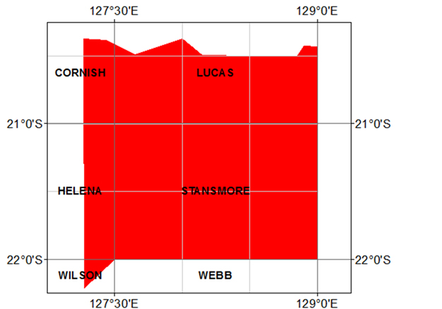
Ngururrpa 2015 gravity survey — final data
Final data from the regional ground gravity survey 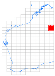 (2.5 km grid) completed in June 2015 will be available from the GSWA website on the Latest Geophysical Surveys page.
Point-located (‘vector’) data and grids can be downloaded free of charge from the Geophysical Archive Data Delivery System (GADDS) or purchased on disk from Geoscience Australia.
Access to previously released geophysical data
Image data from previous geophysical releases can be found on our Regional Geophysical Surveys page. Digital located and grid data can be purchased on media from Geoscience Australia or downloaded free of charge through the Geophysical Archive Data Delivery System (GADDS).
Most recent geophysical data releases
Date Survey Data status
11 Feb 2015 1:250K map sheet images (gravity) Re-published
17 Dec 2014 Sir Samuel – Throssell 2014 gravity (R1018) Final
10 Nov 2014 1:250K map sheet images (TMI, KUT) Re-published
21 Oct 2014 WA magnetic anomaly grid (20 m) v1
Petroleum Open Day — Friday 4 September 2015
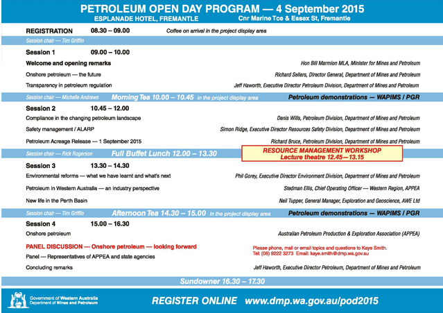
Find out what is going on with onshore petroleum now and in the future in Western Australia. An exhibition featuring Department of Mines and Petroleum activities and information relevant to the petroleum and geothermal industries will be provided by staff from Petroleum Division and the Geological Survey of Western Australia.
Event Details
Date: Friday, 4 September 2015
Time: 8.30 am – 4.30 pm
Venue: Esplanade Hotel
Location: Fremantle
Cost: $110
Contact Details
Contact: Kaye Smith, Petroleum Division
Phone: 08 9222 3273
Email: kaye.smith@dmp.wa.gov.au
Additional Information
Go to this link to REGISTER NOW
For more information, see Petroleum & Geothermal.
Please see the Petroleum Open Day Brochure.
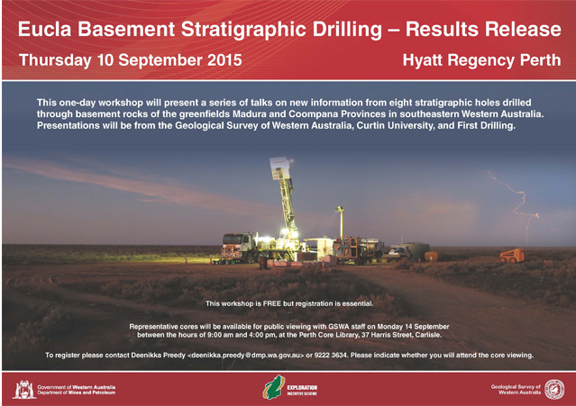
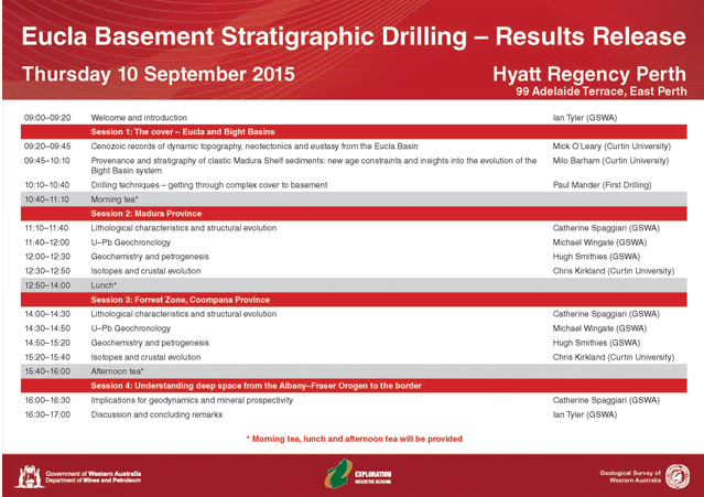
Eucla basement stratigraphic drilling — results release
The Eucla basement stratigraphic drilling program, funded through the Exploration Incentive Scheme (EIS), was established to investigate the greenfields Madura and Coompana basement provinces that lie between the Albany–Fraser Orogen and Gawler Craton, beneath up to 500 m of cover rocks in the Bight and Eucla Basins, Western Australia.
The workshop will include presentations from the Geological Survey of Western Australia, Curtin University and First Drilling.
Topics include:
- Drilling techniques and core acquisition
- Lithological and structural features
- Sulfides, veins and alteration
- Implications for geophysical data interpretations
- Geochronology
- Geochemistry, isotopes and crustal evolution
- Tectonic settings and implications for geodynamics and prospectivity
- Geology of the cover sequences
Date: Thursday 10 September 2015
Time: 8.30 am – 5.00 pm
Venue: Hyatt Hotel
Location: East Perth
Cost: FREE but registration is essential
To register contact Deenikka Preedy (deenikka.preedy@dmp.wa.gov.au) or 9222 3634. Please also indicate whether you wish to attend the public core viewing of representative sections on Monday 14 September 2015, at the Perth Core Library, Carlisle
The schedule of presentations is available for download on the DMP website. Short abstracts will be available on the day, and will be posted on the website afterwards.
Spotlight on a product
Western Australia atlas of mineral deposits and petroleum fields 2015
compiled by
RW Cooper, PB Abeysinghe, CA Strong, LJ Day and F Irimies
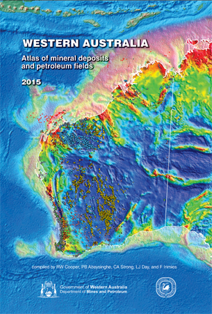 This atlas shows the location of Western Australia’s mineral deposits and petroleum fields, set against a background of simplified geology and cadastral information. The publication is an update of the ‘Western Australia atlas of mineral deposits and petroleum fields 2013’.
In this edition, significant changes have been made to the layout of the atlas. The first pages have been changed from 1:2.5 M to 1:2.2 M scale double-page spreads with insets removed. Larger-scale 1:1 M inset pages, again as double-page spreads, have been produced and placed after all the pages from which they are extracted.
This publication draws together data from a number of sources. The minerals and construction materials information comes from the Department of Mines and Petroleum (DMP) ‘Mines, mineral deposits, and prospects’ database (MINEDEX). The atlas includes major mining-related infrastructure sites captured in MINEDEX, i.e. nickel, alumina, and silicon smelters or refineries but does not display MINEDEX prospects, exploration targets, occurrences, geological observations, most infrastructure types (excluding the smelters and refineries), or the Inventory of Abandoned Mines (WABMINES) mine features.
Information on petroleum fields in Western Australia (onshore and in State Waters), and for adjacent offshore waters controlled by the Commonwealth, is derived from a variety of sources, including DMP’s ‘Western Australian petroleum and geothermal information management system’ database (WAPIMS) and the Petroleum and Geothermal section of DMP’s website. Only major fields are shown, and are identified by a representative well for that field.
A total of 19 344 sites are plotted in this atlas, only some of which display commodity abbreviations. The names of about 10% of those sites (1999 sites) are printed on the maps and appear in the index pages, with priority given to operating mines and larger deposits. More site name information, including commodities, is provided on the 1:1 M scale maps. All petroleum fields are named, and construction material sites belonging to the subset of ’Dimension stone’ are also named and given the full symbol size. Commodity groups are also arranged alphabetically on both the Atlas Reference and Commodity Group index pages.
The index categorizes named sites by their stage of development, using ‘o’ for operating sites and those currently being developed for commercial production, ‘u’ for undeveloped deposits and proposed mines, and ‘c’ representing closed operations, including historic mine sites and those currently under care and maintenance as at January 2015. On the maps, named operating sites appear in bold and black, whereas closed or undeveloped named sites are shown in dark grey. Commercial ownership of named sites (and projects) is also listed in the index. Historic mine sites are not linked to current projects, so commercial ownership is left blank. Mineral commodities, ownership, stage of development, and location of each site have been extracted from the MINEDEX database, which is continually being updated. Digital downloads or live web-based enquiries, including an up-to-date extract of these map-specific data, are available from Online systems.
The atlas is available as a free download or you can pick up a free hard copy from the information counter from the first floor of Mineral House.
Further information
Further enquiries as to the status of the sites and projects included in this publication can be made by sending an email to minedex@dmp.wa.gov.au. The locations and status of petroleum and non-mineral downstream processing operations can also be viewed on DMP’s annually updated Major Resource Projects map. Up-to-date information on Western Australian petroleum fields (onshore and in State-controlled waters) is available from the Petroleum Division of DMP. Field data for offshore Commonwealth-controlled waters is current as of mid-2012; enquiries for the latest information on fields in offshore waters should be addressed to the National Offshore Petroleum Titles Administrator (NOPTA) at info@nopta.gov.au, or to Geoscience Australia (clientservices@ga.gov.au).
GSWA database training 2015 — Perth and Kalgoorlie
The Geological Survey of Western Australia (GSWA) offers FREE training in its databases and online systems. The training is in the form of a presentation with hands-on interaction in most systems.
Topics include:
- navigating the Department of Mines and Petroleum’s (DMP) website
- searching for geoscience publications
- finding digital datasets using the Data and Software Centre
- searching for open-file mineral exploration reports using WAMEX
- searching the mineral drillholes and geochemistry databases
- bringing it all together with the interactive map viewer, GeoVIEW.WA and GeoMap.WA, a standalone GIS viewer for Windows.
PERTH
The Perth training has been divided into separate sessions: one for prospectors, and one for mining companies/geologists.
Venue: Mineral House, 100 Plain Street, East Perth
- Thursday 29 October (prospectors in the morning, mining companies/geologists in the afternoon)
KALGOORLIE
The Kalgoorlie training is open to anyone.
Venue: Room 102 (computer lab), Goldfields Institute of Technology, Centre for Engineering and Mining Training (CEMT), Australian Prospectors and Miners Hall of Fame, Kalgoorlie
- Thursday 5 November
Register
To register for this free training, send an email to publications@dmp.wa.gov.au including your details (name, company name, telephone number), with the location and date of the training you wish to attend.
More information .
New releases
1:100 000 GEOLOGICAL SERIES MAPS
Cardawan, WA Sheet 2748
by Blay, OA and Thorne, AM
Golden Point, WA Sheet 4246
by Quentin De Gromard, R, Howard, HM, and Smithies, RH
Kearney, WA Sheet, 4557
by Eacott, GR and de Souza Kovacs, N
Lake Percy, WA Sheet, 2934
by Romano, SS
Lewis, WA Sheet, 4657
by Eacott, GR and de Souza Kovacs, N
Richenda, WA Sheet 3963
by Phillips, C, de Souza Kovacs, N, and Hollis, JA
Towera, WA Sheet 1951
by Korhonen, FJ, Johnson, SP, Krapf, CAB, and Scheib, AJ
1:250 000 GEOLOGICAL SERIES MAPS
Prince Regent — Camden Sound, WA Sheet SD 51-16 and part of Sheet SD 51-15
by Phillips, C and de Souza Kovacs, N
STATE MAPS
1:500 000 State interpreted bedrock geology of Western Australia, 2014
1:500 000 tectonic units of Western Australia, 2015
1:500 000 orogenic events of Western Australia, 2015
RESOURCE POTENTIAL FOR LAND USE PLANNING
Regionally significant basic raw materials, Carnarvon
Regionally significant basic raw materials, Dongara–Denison
Regionally significant basic raw materials, Geraldton
Regionally significant basic raw materials, Green Head – Jurien Bay
Regionally significant basic raw materials, Leeman–Eneabba
Regionally significant basic raw materials, Northampton
Regionally significant basic raw materials, Wedge Island – Dandaragan
Regionally significant basic raw materials, Exmouth
Basic raw materials, Geraldton – Mullewa
Basic raw materials, Green Head – Three Springs
Basic raw materials, Morowa–Perenjori
Basic raw materials, Northampton–Kalbarri
NON-SERIES MAPS
Iron ore deposits of the Pilbara region 2015
by Cooper, RW
Iron ore deposits of the Yilgarn Craton 2015
by Cooper, RW
GEOLOGICAL INFORMATION PACKAGES
East Yilgarn, 2015: Geological Information Series
South Yilgarn, 2015: Geological Information Series
West Musgrave, 2015: Geological Information Series
DATA PACKAGES
Compilation of geochronology, 2015
Iron ore deposits of the Pilbara region, 2015
Basic Raw Materials, Midwest and Gascoyne 2015
Subscribe to Fieldnotes
 Fieldnotes is a quarterly publication released by GSWA to provide the State's exploration industry and other geoscientists with an update on our latest work and ongoing programs. The publication provides updates on other GSWA products and services and is available free from the Information Centre located on the first floor of Mineral House, 100 Plain Street, East Perth 6004. Find past issues of Fieldnotes here or subscribe to receive a hard copy by emailing publications@dmp.wa.gov.au.
Access GSWA products
You can view and download maps, reports, and digital information free of charge from our website.
Click on these links to take you to the download or launch page for that product:
- Geoscience information, maps and reports
- GIS versions of maps and links to web services
- Interactive geological map (GeoVIEW.WA)
- Explanatory Notes System (ENS)
- Promotional flyers and posters
- GeoMap.WA GIS software
- Mineral deposits and mine information (MINEDEX)
- Mineral exploration reports (WAMEX)
- Petroleum and geothermal information (WAPIMS)
- TENGRAPH online
- Airborne geophysics index (MAGIX)
- Geochronology
- Geochemistry (GeoChem Extract)
- Petroleum and Geothermal Register (PGR)
Hard copies
Maps, USB data packages, and nine premium publications are available to purchase as hard copies from the eBookshop or the First Floor counter at Mineral House, 100 Plain Street, East Perth WA 6004. A new online cart and payment system is in place. Records, Reports, Bulletins and other non-series books cannot be purchased in hard copy but are all available as PDFs to view and download free of charge.
Contact us

For information on publications, email publications@dmp.wa.gov.au
or telephone +61 8 9222 3459/ fax +61 8 9222 3444.
For information on digital data, email the Digital Data Administrator on gsd.dda@dmp.wa.gov.au or telephone +61 8 9222 3816.
Physical address
Mineral House
100 Plain Street
East Perth WA 6004
www.dmp.wa.gov.au/gswa
For more information about GSWA and its products, go to our website.