Cadastre is refreshed from Landgate quarterly.
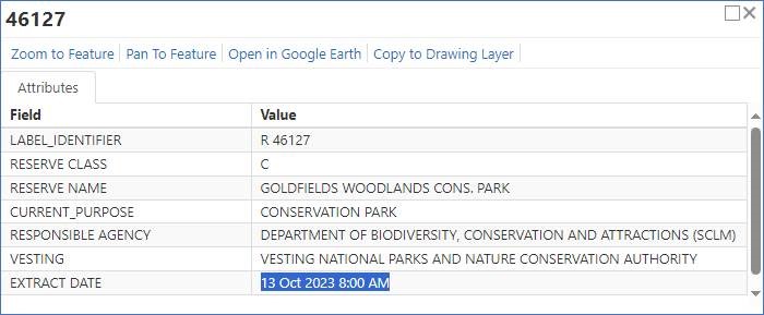
The currency of the data is shown in the information window.
It may take several weeks of preparation before the data extracted from Landgate is ready for display in TENGRAPH.
All the cadastre layers are updated during a maintenance weekend.
The table below shows the date DMIRS received the cadastre from Landgate and the date it is displayed in TENGRAPH.
|
Date Landgate Cadastre Extracted |
Date TENGRAPH Cadastre Displayed |
|
13 April 2024 |
05 May 2024 |
|
13 January 2024 |
04 February 2024 |
|
13 October 2023 |
05 November 2023 |
|
13 July 2023 |
06 August 2023 |
|
13 April 2023 |
07 May 2023 |
|
13 January 2023 |
05 February 2023 |
|
13 October 2022 |
04 December 2022 |
Cadastre Disclaimer
Cadastral data is supplied by Landgate.
It is to be used for information purposes only and is not guaranteed.
The information may be out of date and should not be relied upon without further verification from the original documents.
Where the information is being used for legal purposes then the original documents must be searched for all legal requirements.
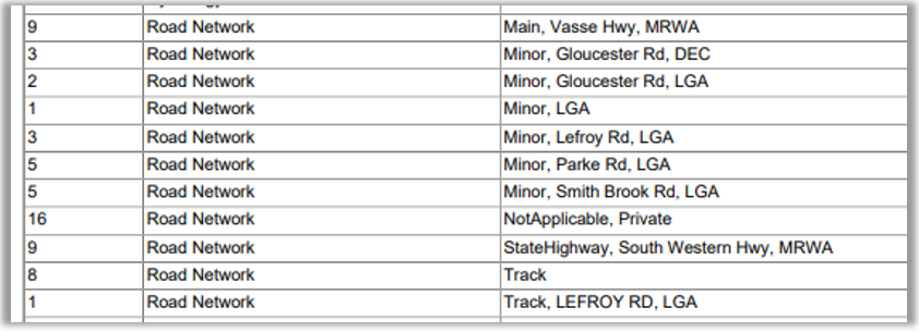
Cadastre road isolations were added from Landgate as polygon data.
The Responsible Agency for roads is recorded in the Services section the Quick Appraisal report.
In general, the management of roads fall into four categories:
- Main Roads WA - for major roads/highways/freeways. Generally between towns and major points of interests. E.g. tourism sites.
- LGA - Local Government roads - all those other than Main Roads which are used for public use. The LGA is responsible for construction and maintenance within their jurisdiction.
- DEC - Department of Biodiversity, Conservation and Attraction roads and tracks. Generally for access within conservation estates.
- Private roads - those for private non-public use e.g. mine site, paroral etc. Maintained by the owner of the property.
An example breakup in the Services section of the Quick Appraisal Report below:
Please be advised the cadastre in Tengraph has been updated and there have been some minor changes.
Table of Contents
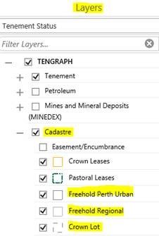
The Table of Contents layer list remains the same with two exceptions.
Under Cadastre:
- Land Act Lot Number - Layer is now renamed Crown Lot
- Freehold Land - This has been simplified and reduced to two layers:
- Freehold Perth Urban
- Freehold Regional
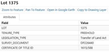
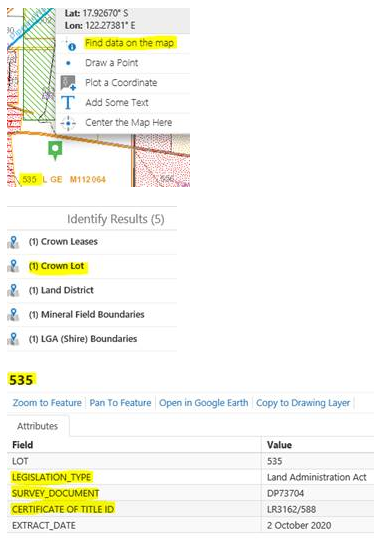
Attributes/Information Display Box
The attributes for each land parcel has changed to provide additional information:
- LOT: is the Lot number
- TENURE_TYPE: is Landgate defined FREEHOLD. This will show CROWN for non-Freehold layers.
- LEGISLATION_TYPE: indicates what Act the parcel of Land is under.
- SURVEY_DOCUMENT: Indicates what type of Survey e.g. DP = Deposited Plan, P = Plan, D = Diagram, SP = Strata Plan. Together with the number assigned to the survey document.
- CERTIFICATE OF TITLE ID: This is the document number for the Certificate of Title.
Searching
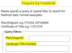
Advanced Land search tool to enquire on Freehold.
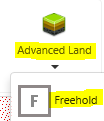
This has been simplified to include searching capabilities for Plans/Diagrams, (Survey Documents) and the Certificate of Title Number.
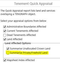
Quick Appraisal
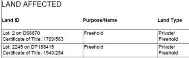
The Quick Appraisal report has been amended to show the Lot number preceding the associated Survey Document.
It now also includes the Certificate of Title.
Please Note : this additional information will only be included if you untick the Summarise Private/Freehold Land in the Quick Appraisal options prior to running the report.
Layers other than Freehold
If you wish to determine the Survey Document, Certificate of Title and relevant Act information for cadastral layers other than Freehold, you will need to check the attributes for the individual Lot parcel in the Crown Lot layer.
Reminder: Cadastre doesn't display by default.
The layer must be turned on. Also it is scale dependant, meaning as you zoom in and out layers will become visible
Topography is refreshed annually from Landgate.
TENGRAPH has been compiled from various data sources received from a number of agencies. No responsibility is accepted for any error or omission. Confirmation of the boundary extents and attribute information of land types should be sought from the relevant agency.
For more information refer to the Map Layer Metadata links embedded within TENGRAPH and the Description of Land Type Categories information brochure.