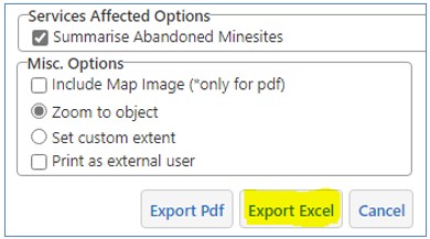
TEN-173: An option to export a mining tenement Quick Appraisal report as an excel spreadsheet has been added.
TENG-267: Help links have been added to the following Search Tools:
- Tenement Holder
- Colour Tenement by Holder
- Recent Activity
- Tenement Release
- Dead Tenement
- Combined Reporting Number
- Historical Tenement Maps
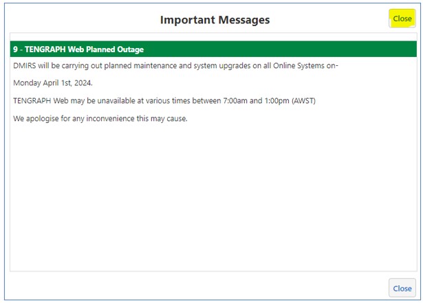
TENG-270: An additional Close button has been added to the "Important Messages" pop up window.
TENG-272: The redundant Map Layer "Native Title Determination & Outcomes" has been removed from the Snappable Layers panel.
TENG-275: The new Departmental name Department of Energy, Mines, Industry Regulation and Safety (DEMIRS) has been updated on all PDF prints and TENGRAPH Web headers.
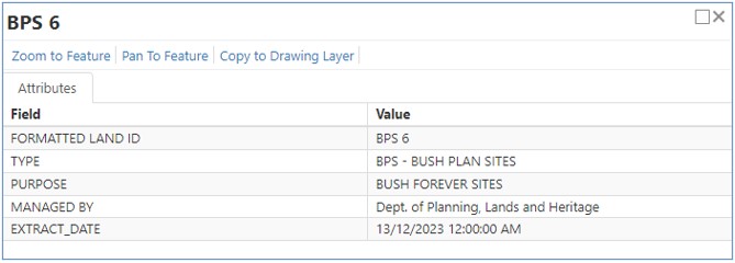
TENG-282: Map Layer name change - The Bush Plan Sites Layer is renamed as Bush Forever Areas.
TENG-280: The following attributes are removed from the Bush Forever Areas information window display.
- OFFICIAL NAME
- FILE REF
- START DATE and;
- END DATE
Additional attribute shown.
- EXTRACTION DATE
TENG-288: eMiTS and TENGRAPH "rest wrapper dll code" change to help complex Quick Appraisals finish before they time out.
TENG-289: Metadata Links for department of Water and Environmental Regulation Layers added.
- Proposed Water Reserve
- Proposed Catchment Area
- Proposed Underground Water Pollution Control Area
TENG-294: Search by Minesite bug fix.
Mine sites with an apostrophe as a part of the name caused an error e.g. Search - Minesite - "Huntly - O'Neil".
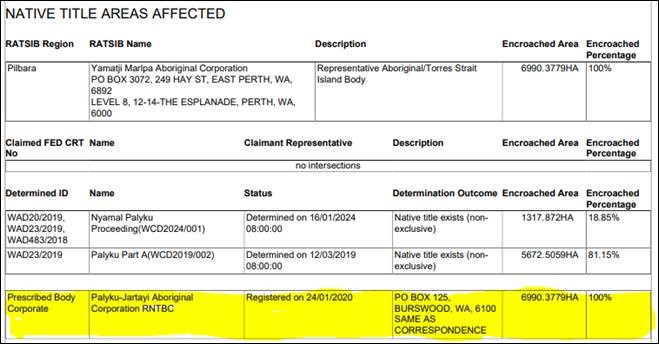
TENG-295: Native Title Prescribed Body Corporate details are now provided in the Quick Appraisal Report. The Determination Status is also shown.
TEN-81 and TENG-242:
The option to print an A4 PDF Legend with your A4 / A3 Map Print has been added.
The TENGRAPH legend PDF can be in Landscape or Portrait format. It is printed on a separate page and is scale dependant, in other words it will only print the legend for layers displayed at the map scale.
Tip: Simplify the legend by turning off irrelevant map layers before requesting a legend print.
TENG-200: Petroleum Prime Areas, a new TENGRAPH Map Layer displaying designated areas within Western Australia, reserved under section 28 of the Petroleum and Geothermal Energy Resources Act 1967 for future acreage releases.
TENG-265: New Help Button links to the TENGRAPH User Manual. Opens on the relevant page for instructions on how to -
Quick Appraisal Interactive Map and A4 PDF Report Enhancements
FBES-11048: Quick Appraisal PDF Reports changed to use the new National Native Title Tribunal NNTT Data.
Affected Layers:
- Representative Aboriginal/Torres Strait Islander Body Areas
- Native Title Determination Outcomes,
- ILUA Areas and
- Native Title Claims
TENG-173: Related to above (FBES-11048). New Native Title Map Layer Intersections implemented for Appraisal Reports.
TENG-174: Include Native Title Determination Outcome details in Appraisal Reports.
FBES-11065: The status shown on Quick Appraisal Reports affecting Petroleum/Geothermal Titles with the prefix STP or GEP's have been corrected.
Patch release fixing bugs introduced with V2.0.27
TENG-261: Unable to Explode a Polygon into Lines and points workflow issue.
TENG-262: Create Polygon from Points - Coordinate Panel display issue.
TENG-231: New functionality to edit plotted coordinates displayed in Decimal Degree (DD) format.
TENG-248: KML files removed from the Data Upload help documentation.
TENG-249: Provides a Create Line/Polygon by Traverse "Help" link to the TENGRAPH user manual.
TENG-253: Geological 1:100,000 and 1:250 000 map sheet index updated.
TENG-254: Information Window - Section 19s displaying incorrect date (8 hours out) fixed.
TENG-247: Includes Metadata Links for the following recently added Map Layers:
TENG-172: Three new Map Layers have been added to the Native Title Folder.
- Registered Native Title Corporates Areas (RNTBC).
- Section 31 Agreements.
- Future Act Objections.
These layers are for information purposes and will need to be turned on to be viewed.
Display Scale Range 1:35 to 1:9,244,648.
TENG-173-4: Native Title Determinations and Native Title Determination Outcomes have been merged into a one Layer called Native Title Determination and Outcomes. The information is now sourced directly from the National Native Title Tribunal NNTT.
ILUA Areas and Native Title Claims are now also sourced from NNTT instead of Landgate.
The Aboriginal Representative Body has been updated from NNTT and is now called Representative Aboriginal/Torres Strait Islander Body Areas (RATSIB).
Note: The Quick Appraisal Reports will continue to show encroachments with Native Tile map layers sourced from Landgate until eMiTs is updated. (ETA Mid-October)
TENG-224: New Map Layer.
Geoheritage Sites displayed in GeoVIEW.WA have been added to the Special Category Land Folder.
Display Scale Range (1:32 to 1: 2,311,162).
Encroachments with Geoheritage sites will be included in Quick Appraisal reports once emits is updated later this year.
TENG-229: The appearance of the WA Locality Map embedded in A1 plots has been improved.
TENG-236: A new Aboriginal Heritage Folder has been created.
It contains the following Map Layers:
- Aboriginal Heritage Places
- Aboriginal Heritage Surveys
- Tjiwarl Identified Cultural Areas (NEW Layer)
- Tjiwarl Significant Cultural Areas (NEW Layer)
Tjiwarl Cultural Areas are supplied by the Tjiwarl Aboriginal Corporation. Please contact admin@tjiwarl.org.au for any queries regarding this data.
Intersections with Tjiwarl Cultural layers are not included in Quick Appraisal Reports.
TENG-167: Metadata links added to the GDA94 and AGD84 Graticule Map Layers.
TENG-191: The WA Heritage Site Layer Name has been renamed as the Heritage WA State Register.
TENG-222: Aboriginal Heritage Places - New map layer added for information purposes.
TENG-225: The Gazetteer/Place Name search data source has changed. It is now called Search by Geographic Place Name the data will be updated monthly with new place names from Landgate.
TENG-227: Three new map layers for the display of Geothermal Applications, Geothermal Releases and Geothermal Titles have been added to the Petroleum Folder.
TENG-16: Decimal degrees added to the dynamic Latitude / Longitude coordinate display.
TENG-204: A 'What's New' information button on the Getting Around Tab. It opens information about recent TENGRAPH enhancements and improvements.
TENG-175, 179, 180, 182, 185, 211, 215: Drawing and plotting improvements:
- A new Create Point on a Line tool.
- An improved Create Line and Polygon by a traverse tool.
- Enhancements to the GDA 84 to GDA94 coordinate transformation tool.
- Explode Drawing to lines and points enhancements.
- A new Create Polygon tool using three or more plotted points/coordinates. The Convex Hull method used to determine the polygon shape.
- Plot coordinate label on map display reinstated. Users have the option to toggle the label on/off.
GEOCORTEX SOFTWARE UPGRADE:
From:
Services version: 4.12.0.0064
Client version: 4.12.2.2481 (HTML5 (Desktop))
To:
Services version: 4.14.2.0
Client version: 4.14.2.4 (HTML5 (Desktop))
TENG-171: Colour tenements by holder, selection enhancement. Users can now select multiple holders to colour on the map.
TENG-177: Option to print Geographic coordinates (Print Object Details) as decimal degrees.
TENG-181: Improve the TENGRAPH Map highlight properties for complex objects.
TENG-187: Alibility to Turn On 5 Minute Petroleum Block Labels.
TENG-188: Add Metadata URL link for the WAMEX Tenements (Access Exploration Reports) map layer.
TENG-189: Add Metadata URL link for the Historical Mining Tenement Map index layer.
TENG-186: ANCA Wetlands map layer Metadata URL link change.
TENG-190: The Help Acknowledgments PDF document updated.
TENG-144: Map layer name change. Aquaculture and Pearling Licences and Leases now called "Aquaculture Sites and Pearling Leases".
TENG-163: Hidden SDI Map Layers replaced by the TENGRAPH Topography base map have been removed.
TENG-165 & TEN-55: Quick Appraisal tenement intersection tolerance modified. (Implemented - 6/10/2022)
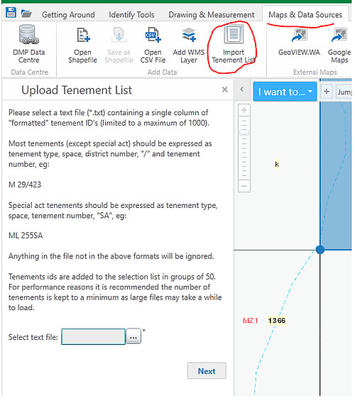
TENG-148: Import Tenement List (*.txt, *.csv file) server error fix.
TENG-158: TENGRAPH A3 map prints requested from Front Counter Mining Registrar PCs are now emailed for staff to print. Implemented due to the front counter printers no longer supporting A3 TENGRAPH Map Prints.
TENG-12: Improved access to the mineral exploration reportes stored in the Western Australian Mineral database (WAMEX).
TENG-124: The superseded "Geodownload.dmp.wa.gov.au" metadata URL links changed to use the cloud.
TENG-150: The "File Notation Areas (Historical)" map layer has been removed.
TEN - 58: Search by Map sheet improvement
TEN - 60: Language settings are changed for United States English to Australian English (i.e Color to Colour)
TEN - 118: Results Table View - column alignment with headings fix
TEN - 158: Regional and Urban Road Isolations implemented as part of the quarterly Cadastre LANDGATE Layer update
TENG - 77: Allow users to run a single Graticular Block Quick Apprasial
TENG - 119: Carbon Farming/Sequestration Projects map layer added in TENGRAPH
TENG - 122: Chrome users missing scroll bar for Dead Tenement, Colour tenement by Holder searches etc. fix
TENG - 123: Contains Data and Software Centre (DASC) website URL changes
TENG - 126: Snappable Layers List - modified to match the Map Layers List
TENG - 137: TENGRAPH changed to run on Native Edge
The following improvements have been implemented:
TEN-171: The out of date NT (Northern Territory) Petroleum Wells map layer has been removed from TENGRAPH.
TENG-95: Includes additional Petroleum 2D and 3D Seismic line and survey information.
TENG-120: TENGRAPH Feedback emails changed to use the Department's new relay mail server.
The following improvements have been implemented
TEN-161: The currency of the TENGRAPH Topography cached basemap updated and new layers added.
TENG-100: 5(1)G and 5(1)H Reserve Label Property Change.
TENG-102: User Id Details missing from Print Object Details PDF HQ Maps.
TENG-103: Improvement to Upload Tenement Text files List Workflow.
TENG-105: Search Tenement by Multi-Holder Enhancement.
TENG-108: Airfield Scale Display Change.
TENG-110: Landgate Aerial Imagery date display fixed.
TENG-111: The number of Results in List View Panel increased.
TENG-112: Minor enhancement for Closed Road label display.
TENG-114: Enhancements to the Print Object Details - PDF Report.
TENG-115: General Improvements to the Map Label Display.
The following improvements have been implemented:
TENG - 79: Tenement Information Window - Move Field Book Column next to the Surveyor Name.
TENG - 82: Identify Tools - Rationalise the Identifiable Layer List.
TENG - 85: Search and Colour by Combined Reporting Number enhancement.
TENG - 86: Changes to the WAMEX interface for Combined Report Number Searches.
CHG0037862: A1 plot email change - SMTP server changed to use the new Azure mail relay server.
The following improvements have been implemented.
TENG-15: Missing Mining Tenement Relationship information from the tenement information window. Only some tenements are missing (fixed).
TEN-52: Improvement to the Mines and Mineral Deposits (MINEDEX) map display. Infrastructure Mine sites are represented with new map symbols.
TENG-71: Removal of Redundant Map Layers from the Land Map Service.
TENG-72: Map Service Historical Tenement Label Display Configuration.
TENG-74: Hide the MINEDEX map service name from Public users Legend panel.
TENG-75: 1:2,000 Map Print Scale added to the dropdown scale list.
TENG-73: The Vector Map Print Option removed from the TENGRAPH Web Print Window.
TEN-131: State Agreement Act Sections - Date Display fix.
TEN-162: Mining tenement applications plotted today in TENGRAPH will now be included in the RECENT Activity Search Results.
TEN-169: Enhancement made to the A1 Portrait Legend display.
The following improvements have been implemented.
TEN - 51: The DAA Heritage Survey Areas layer renamed to Aboriginal Heritage Survey Areas.
TEN - 53: The Geomorphic Wetlands layer removed.
TEN - 89: The Cadastre Layers, Appraisal and Search Tools modified to accommodate the new data format supplied by Landgate.
TEN - 122: Time stamps shown within the Historic Boundary View window expanded to show seconds.
TEN - 144: The Vector Print Option removed from public view.
TEN - 150: Search by Petroleum Pipeline enhancement.
TEN - 153: Search by 5HR Reserve - Information window fix.
TEN - 157: New Petroleum layer added to accommodate Geothermal Special Prospecting Authority titles.
TEN - 164: The Lakes layer removed from the Land Folder. (Already displayed on the Topography Basemap.)
FBES - 10006: 1:100 000 and 1:250 000 Geological Sheet Index added. Users can now download Geological Map Sheets or Map Legends seamlessly from TENGRAPH.
The following improvements have been implemented.
TEN - 110: Additional Metadata Links
TEN - 117: Add the Extract date to the DAA Heritage Survey Information Window.
TEN - 120: Public Users are unable to print shapefile object details.
TEN - 122: Historic Boundary View - Expose Boundary time in Seconds.
TEN - 123: Drawing & Measurement - Select Snapping Layers Issue.
TEN - 125: Remove the built-in Query against All History and Tenements.
TEN - 127: Remove/hide State Agreement Act Area from Search.
TEN - 131: State Agreement Sections - Attribute Display Issues (TGW Internal)
TEN - 132: New Enhanced Plotting Tools. (TGW Internal)
TEN - 134: Remove the FID_ field from the SDI TRANSMISSION LINE layer.
TEN - 135: Rename WANow_Index to Landgate Aerial Imagery in the Results panel.
TEN - 136: Map Print scales - add 1:400,000 and 1:300,000 to those available.
TEN - 137: Native Title Determinations - TGW & TGWint Field Name Typo Error
TEN - 2618: Tenement Boundary History - Minor spelling mistake in message.
TER - 2796: Incorrect FNA ID: shown on Quick Appraisal Report.
The following improvements have been implemented.
TEN - 12: Tablet and Smartphone devices - Plot coordinate fix.
TEN - 37: Topography Basemap large scale display issue fix.
TEN - 80: Standard Survey Marks - Link to Landgate's Online Geodetic System (GOLA) provided.
TEN - 103: Add new tenement boundary reasons in history.
TEN - 104: Remove using CRN column to autocomplete in searching by Combined Reporting Number.
TEN - 106: Petroleum Wells - feature link does not work.
TEN - 108: Construct Polygon - Print Objects Details MGA Northing coordinates accuracy issue.
TEN - 111: Print Map Scale at 1:15,000 out of order in the Public drop down list.
TEN - 112: Additional Large Scale Map Printing options provided.
TEN - 113: 'Definition Query' removed in FNA/Section19 Public searches.
TEN - 114: Active Section 19 boundaries changed to display at the same scale as mining tenements.
TEN - 115: Additional Aboriginal Community Information displayed when selected. The Date Format display is now consistent between Public and Internal users.
TER - 2524: Allow users 'Zoom in' up to 1:35 scale on the map display.
The following improvements have been implemented.
TEN - 2: A4 Portrait Raster Print Plugin issue.
TEN - 48: Replace the Special Category Land South West Native Title Settlement Map Layer with Special Agreement Settlement.
TEN - 54: The symbol representing Seconds " is missing from Print Object Details PDF reports.
TEN - 79: Clip Polygon spelling error fix.
TEN - 92: Create line by bearing and distance tool isn't working as expected.
The following improvements have been implemented.
TEN - 48: Replace the Special Category Land South West Native Title Settlement Map Layer with Special Agreement Settlement.
TEN - 92: Create line by bearing and distance tool isn't working as expected.
TEN - 79: Clip Ploygon spelling error fix.
TEN - 107: Users are unable to Print PDF maps with the 1:100,000 or 1:250,000 Topography Mosaic Maps displayed.
The following improvements were implemented into TENGRAPH Web Public
TEN - 43: Unable to Search by Combined Reporting Number 93/2007
TEN - 86: Combined Reporting Number Search, Missing Step
The following improvements have been implemented.
TEN - 1: Unable to create a Form 21 containing a hole.
TEN - 4: Upload Coordinates - Add Spatial Reference in GDA94 Lat/Long.
TEN - 5: Upload Coordinates - Add MGA Zone 48 Spatial Reference.
TEN - 6: TENGRAPH Web HTML5 (PUBLIC) link to WAMEX exploration reports is broken. (Chrome issue)
TEN - 8: Tenement Type Theme - TEN_TYPE attribute field display.
TEN - 12: Tablet and Smartphone devices - Plot Coordinate & Coordinate Display.
TEN - 15: Bookmarked Locations sensitivity menu issue.
FBTWAP - 4: Native Title Claim & Determination, Federal Court Number Attribute - Spelling error.
The following improvements were implemented into TENGRAPH Web Public.
Geocortex Client software upgraded to 4.12.2.2481 (from 2.10.1).
TER-1714 - The overall performance of TENGRAPH Web, the application pool recycling time have been changed to every 3 hours. (Preventing time out issues.)
TER-1618 - Dead Tenements shown as Live in the holder Search results. (Now shows correct status)
TER-1141 - Printed PDF Map, position of text placed by user issues.
TER-1121 - Additional Editing Tools - Create Hole in Polygon and Clip Polygon.
TER-968 - Hydro Point Topography feature labels not printed on maps between 1:50,000 and 1:100,000.
TER-966 - Unable to display Cadastre, Petroleum or Mindex sites with Shapefiles. (Fixed by V12)
The following TENGRPH Web (Internal) issues have been resolved.
TER-634 - Horizontal scroll bar missing from the Tenement Information window.
TER-1523 - PDF Raster Map Print, Plotted Coordinate Issues fix.
TER-1618 - Dead Tenements shown as Live in the Holder search Results.
FBES-10020 - Improved emits - TENGRAPH communication.
FBES-10037 - Fixes a "Cannot find tenement" error.
The following improvements were implemented into TENGRPH Web Public.
TER-634 - Add Horizontal scroll bar missing from the Tenement Information window.
TER-898 - Fixes the Survey Information missing from tenement information window affecting M70/1378, M51/427etc.
TER-1222 - The Information window becomes stuck behind main toolbar fix.
TER-1474 - Allow for the export of a point constructed at the end of a line as a shapefile.
TER-1523 - PDF Raster Map Print - Plotted Coordinate Issues fixed.
TER-1572 - Terms of Use URL link update.
TER-1618 - Dead Tenements shown as Live in the Holder search results fixed.
The following improvements were implemented into TENGRPH Web (Internal).
Geocortex Essentials Client Viewer V4.12.2 upgrade. (from V2.10.1).
Includes the same improvements as the TENGRAPH Web (Public) release dated 12 March 2020.
The following improvements were implemented into TENGRPH Web Public.
TER-975 - Export/Copy to Drawing archived tenement boundaries from the Tenement History view.
TER-1151 - Includes an option to Undo/Redo edited drawings.
TER-1152 - Unable to locate a crown reserve with a number < 1000.
TER-1176 - Split the TENGRAPH popup message for internal and external users.
TER-1215 - Create line by Bearing and Distance from a plotted coordinate bug.
TER-1218 - Dead Tenement Search - User tip.
TER-1219 - Recent Activity - Tenements granted bug fix.
TER-1224 - Advanced Tenement Searches - Sort tenements by Tenement ID in the Results panel.
TER-1237 - Search by Holder workflow error.
TER-1298 - Users are unable to search for Standard Survey Marks.
The following improvements were implemented into this version.
TER-609 - Improvements to the WAMEX views.
TER-915 - HQPrint for TGW and TGWINT severe error code 103800 shown in log file resolved.
TER-1055 & 1129 - Tengraph Web displaying an incorrect date (American) format on some browsers resolved.
TER-1120 - A downloadable "Getting Started PDF Guide" to assist new users navigate around the system.
TER-1103 - Historic Tenement Plan Start - End Date Display error.
TER-1116 - Print Object Details - Second page DMIRS Header Issue.
TER-1166 - Recent Tenement Activity Search user tip text changes.
The following issue(s) have been resolved:
TER-1039 - Bookmarked Location Map Scale different between the Public and Internal application.
TER-1019 - The Tenement Action menu is missing the Quick Appraisal options for Public users.
TER-1062 - Transparency issue with Crown Reserves and Unallocated Land.
The following issue(s) have been resolved:
TER-1055 - Tengraph Web displaying an incorrect date (American) format on some browsers
Database views changed to use custom data format 'dd MMM yyyy hh:mm:ss tt', not default
The following issue(s) have been adressed
TER-1016 TGW TGWINT - HQPrint GP services changed to recycle hourly
To improve the overall performance of the map prints TGWINT and TGWEXT HQPrint GP appraisal services changed to recycle hourly
The following issue(s) have been addressed
TER-1015 TGW - Application pool recycling time changed
To improve the overall performance of Tengraph Web, the application pool recycling time have been changed to every 4 hours, commencing at 2am.
TER-928 - Search by Holder, not always returning pending tenements in the results for some departmental users fixed.
TER-979 - Public print workflow error when printing plotted coordinates fixed.
TER-1021 - Public Tenement Release time display issue fixed.
"New multi-browser, multi-device version of Tengraph Web. This version of Tengraph Web will run on current Desktop Web browsers without the need for plugins (ie Silverlight). It is also designed to operate on android and apple IOS based tablets and handhelds"
The following enhancements and bug fixes were made.
12869 - Search by Holder or Colour by Holder with an Apostrophe does not work.
12965 - The TENGRAPH Web to WAMEX Link is not working.
12881 - Road Reserve GE number is removed from the Results.
12889 - Display survey feild book and project ID in TGW.
12940 - Remove the Combined Reporting Number from the Information window. (Use the Combined Reporting Number search tool).
12946 - View Tenement Holder - "Typo" in Continue button fixed.
10797 - Ability to run Internal Quick Appraisal Report for Special category Lands.
12877 - Ability to run Quick Appraisals for Historical FNAs and Section 19s.
12973 & 12667 - Removed fields fron exported .csv and shapefiles.
The following enhancements and bug fixes were made.
12740 - Opening WA map display updated.
12730 - Help Link from TGW to "Safety First" web page.
12739 - Help Link from TGW to "Where Can I Go Prospecting" web page.
12707 - Commonwealth Petroleum Title Holder Details.
12703 - Minor attribute display changes affecting Land Divisions, Suburban and Estate Areas.
12763 - A3 Portrait Map not printing Landgate Aerial Imagery fixed.
12768 - Date of Landgate Areial Imagery provided.
12777 - Form 21 Attachment 1. Exploration licence spelling and date fixes.
12800 - Aboriginal Communities layer updated.
12790 - Commonwealth Heritage Listings - Attribute Change.
12791 - NAtional Heritage Listing Layer - Attribute Change. URL link to the Department of Environment and energy has been added.
12827 - Quick Apprasial Enhancement - Certificate of Title with the Plan on Lot number is now shown with any affected freehold land. (Remember to untick the summerise button Private/Freehold Land checkbox before running the quick apprasial).
12816, 12814, 12850 - Minor Quick Appraisal formatting and bug fixes.
The following enhancements and bug fixes were made.
12683 - The Townsite Layer updated to include LGA Townsites.
12664 - External users can now save their constructed Drawings as a shapefile.

12644 - Shapefiles exported from TGW are now recognised by ArcMap with the GD94 datum.
12629 - DMP Data Centre icon changed to DMIRS

12643 - The Search by Graticule, Form21 Attachment workflow error fixed.
12595 - Colour by tenement holder workflow error fixed by a workaround received from Geocortex.
12145 - TGW email updated with new Department name.
The following enhancements and bug fixes were made:
12602 - External users are unable to print Landgate Aerial Imagery on their maps - Issue fixed in this version.
12575 - External user request. The number of tenements uploaded from a Text file into the Results List increased from 100 to 1,000.
System Improvement for TENGRAPH Web Release 1.0.6 - 30 January 2018
MAJOR Performance bug fix:
Tenement searches should now be finishing and displaying on the map quicker.
The following enhancements were made:
12511 - Application configuration settings changed to address workflow performance issues. (In particular the Tenement Search and Enquiry)
12232 - A new hard coded URL link to open the Description of Land Types PDF Document implemented.
12485 - GDA94 Graticules selected from the map display can be exported and saved as a Shapefile.
12501 - The TENGRAPH Aerial Imagery link changed to a new Landgate Imagery service. (Note the ne new Landgate / SLIP watermark displayed on the map.)
12486 - A new "Drawing and Measurement" tool that explodes polygon drawings into points and lines has been implemented.
12512 - References of all 'Proposed 5 G' reserves changed to display as 'Proposed 5 H reserves'
12529 - The accuracy of the Combined Reporting Number Search has been improved by getting the results directly from WAMEX instead of the SDI database.
System Improvement for TENGRAPH Web Release 1.0.5 - 01 December 2017
The following issues have been resolved:
12268 - The Southwest Native Title Settlement layer display fixed.
12286 - Aboriginal Heritage Areas - Gazetted, the map layer properties modified to make more visible.
12287 - New Display and Label properties affecting Commonwealth and World Heritage Layers.
12360 - Export to Google Earth (KML File name changes)
12359 - A new Electricity Transmission lines layer.
11658 - New independent Transparency Slide bars for the Topography and Geology Map Mosaics.
12145 - The "Description of Land Types in TENGRAPH" PDF document has been revised.
12406 - TGW Problem importing CSV files with Zone 50 grid coordinates fixed.
12419 - Saving Projects 'Share with everyone' default setting changed to unchecked
12457 - Tenement text file upload limit increased from 50 to 100.
12461 - Create point by MGA map coordinates bug fix.
Emits related
12130 - Any affected Threatened Ecological Communities will be summarised in the Quick Appraisal Report with the next emits release.
System Improvement for TENGRAPH Web Release 1.0.4 - 09 October 2017
- The WA coastline and lakes on the Topographic base map display updated.
- Topography and Geological Map Mosaics Metadata links updated.
- The "Help & Feedback" Acknowledgements document updated.
- The "Share Current Map" Tool added to the "I want to..." drop down menu.
11480 - Improved pixel tolerance for identifying point features on the map display using the "What's here" facility
11578 - The standard tenement status legend removed from maps generated in the Tenement Type & Survey Map layer theme.
11801 - Ability to print maps (& Print object details) over Cocos (Keeling) Island Zone and Commonwealth Petroleum titles. (Zone47) implemented.
12169 - Water (Unallocated Crown Land) Cadastre Layer added.
12223 - Road Network and Rivers (Major and minor watercourses) removed from Land Map service. (Now displayed in Topography Base map)
12122 - Amalgamation Quick Appraisals - Now includes the EL tenement Id in the report.
12192 - Pastoral LEASE HOLDER removed from the information display.
12196 - Attribute Display window enhancements.
12226 - Quick Appraisal Service "Unavailable" error message updated to give a better indication as to the cause of the error.
12239 - The TENGRAPH Web Getting Started Guide updated with the new DMIRS department name.
12265 - Raster Map print enhancements.
12242 - A1 Vector Map Legend Layer Name Enhancement.
12283 - Users can now search Land Act Lot by CT & PIPARCEL. Attribute Display also updated with CT & PIPARCEL details.
12284 - Wellhead Protection & Reservoir Protection Zones - display enhancement.
12297 - The Search Tenement Holder workflow improved. (Search changed to use POST instead of GET for the map service query.
12148 - New Quick Appraisal option to Select Native Title Determination Outcomes (internal users only)
- Section 19 Formatted Land Id shown in the label.
- 3 Nautical Mile Layer update
Quick Appraisal Enhancements implemented 21st Sept. 2017
11895 - Quick Appraisal Results now show the Section 19 Land Id.
11896 - The ILUA Subject Matter is now included in the Quick Appraisal Results.
12248 - TENGRAPH Web - Quick Appraisal report has been enhanced to show any intersections with Offshore Areas in Ha.
12249 - Better Appraisal area calculations for small overlaps. - Spheroidal Calculations bug fix.
12179 - Dead tenements are now sorted by their Tenement ID: in the Quick Appraisal Report
12264 - Quick Appraisal changes for the new Water (Unallocated Crown Land) Layer
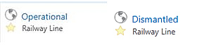
12269 - The Railway line status (Dismantled or Operational) is now shown in the Quick Appraisal results
11925 - Quick Appraisal Report now shows The Crown or Pastoral lease Quick Appraisal ID shown in the header. (Only affects Internal users)
12233 - Intersections with EPA Assessment Areas have been removed from the Quick Appraisal Report (Only affects internal users).
System Improvement for TENGRAPH Web Release 1.0.3 - 27 July 2017
- Updated with the new Department branding on all prints and reports reflecting the Machinery of Government (MOG) changes.
- Allows users to copy imported shapefiles to a drawing
- This version also fixes the Search by Place Name/Gazetteer bug.
System Improvement for TENGRAPH Web Release 1.0.2 - 14 July 2017
Major enhancements
- Performance improvements.
The increased TENGRAPH Web usage (344 users in June) has enabled our IT people to analyse the system performance for bottlenecks. As a result access to the Topography base map has changed and now redraws faster. The Cadastre layer group now has its own map service which improves the land refresh rate. Security checks have also been rationalised improving the overall performance.
- New Cadastre Map Service
The Cadastre layers have been taken out of the Land map service into their own map service.
These changes have been implemented for better performance and provide the cadastre layers with an independent transparency slide bar.
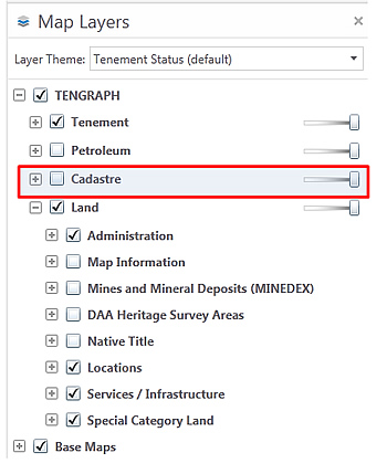
Note: Cadastre will not display on your map unless the check box is ticked. ![]()
Other enhancements
12086: The brackets have been removed from the main header

12093: Tenement History boundary insert date display changed to another field
12032: New enhancements to the Create Line by bearing and distance tool
12018: Minor enhancements and user tips to the Quick Appraisal Constructed Object/shapefile tools
12109: The Standard Survey Mark (SSM) information window display is now attributed
11406: Petroleum title search enhancements and user tips.
12119: The Railway Line status is shown in the results when selected on the map.
System Improvement for TENGRAPH Web Release 1.0.1 - 08 May 2017
Major Enhancements
- New Help system with training videos.
Click here to access TENGRAPH Web Training Videos
The FAQ, Drawing Tools and Quick Reference Help are now linked to the Department’s Open Text Website Management (WSM) system
- A New Google Maps link has been implemented. Clicking on the icon as shown below will open Google Maps with the same extent as your current TENGRAPH Web map display.
Minor Enhancements
Case No 12017 - All A1 plots are now emailed to user. (Public users can still download A1 plots from front counter Kiosks.)
Case No 12006 - Search for Historical Maps typo mistake fixed
Case No 11998 - The number of Attributes exported from Recent activity results has been reduced.
Case No 11981 - An Abandoned mines inventory link to MINEDEX implemented
Case No 11368 - A Petroleum wells link to WAPIMS implemented.
Case No 11952 - Help pages, Terms of Use - Disclaimer
Case No 12002 - The "Open Google Street View Here" option from the "Context" map display menu doesn't work due to licencing issues and has been removed.
System Improvements for TENGRAPH Web Release 03 April 2017
Enhancements
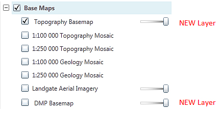
New Base Maps
- A new cached Topography base map displaying the road network, rivers and coastline (Default display) has been implemented improving the map redrawing speed.
- An option to overlay the DMP (GeoVIEW.WA) Basemap.
User Tips
- More user tips placed throughout the application.
Other TENGRAPH Web enhancements and bug fixes:
Case No 11921 - Tenement Survey field name changed from SURVEYED to SURVEY STATUS
Case No 11845 - Constructed Graticule Blocks Missing (bug) from some Map Prints fixed.
Case No 11828 - Recent Activity search options changed to work on individual activity types.
Case No 11829 - Allows users to run a Quick Appraisal Report affecting an open Shapefile drawn on the map.
Case No 11831 - Allows users to extract mining tenement selections as a CSV file
Case No 11829 - Fixes the missing asterisk from surveyed inspection tenements labels e.g. (M 45/57 and M 45/284)
Case No 11867 - The map scale bar prints in a better position
Case No 11833 - The GE number has been removed from exported dbf and csv files
The "State Agreement Act Area" map layer has been removed as it does not contain any information.
System Improvements for TENGRAPH Web Release 19 January 2017
The following issues have been resolved:
Case No 11806 - Graticule polygons can be selected to run Quick Appraisal Reports
Case No 11776 - The Copy to Drawing tool has been fixed to work on all TENGRAPH layers
Case No 11801 - Maps can now be printed over Christmas and other offshore islands located in Zones 48 & 49. (Bug fix)
Case No 11782 - Information Panel Results reflect the correct road network displayed on the map.
Mountains, Lakes etc. selected on the map display are correctly listed in the results panel.
Case No 11341 - The 8:30am Release time display affecting exploration licences has been fixed.
Case No 11781 - Raster prints now include base maps (Bug fixed)
Case No 11789 - The Insert Date Stamps affecting Pending Amalgamations and Restorations are no longer visible.
Case No 11790 - All Holders Field name has been added to the attribute display window affecting Petroleum Titles.
Case No 11798 - Dead superseded surveyed tenements are now printed on Vector generated maps. (Bug fixed)
Case No 11754 - Some Quick Appraisal results incorrectly show an encroachment greater than 100%. (fixed in next emits release)
Case No 11694 - Quick Appraisal of Freehold Land bug fix. (Freehold Land must be selected from the results for it to run.)
System Improvements for TENGRAPH Web Release 09 December 2016
Enhancement
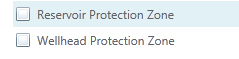
- Reservoir and Wellhead Protection Zones map layers have been added.
The following issues have been resolved:
Case No 11684 - A Getting Started Guide is available from the “Help & Feedback†Tab
Case No 11687 - The Quick Reference Manual has been updated
Case No 11750 - The Surface Water and Ground Water Results panel display have been improved.
Case No 10997 - Base maps have a metadata statement included
Case No 11365 - Results panel - an option to view Historical WAMEX tenement boundaries.
Case No 11394 - Public users allowed to Print Object Details directly (Instead of emailing them)
Case No 11147 - Extract Tenement Drawings created in the Survey Theme
Case No 11731 - Quick Appraisal Improvement
Case No 11750 - SWA GWA Results Display
Case No 11696 - Quick Appraisal report - multiple holder issue
Case No 11721 - Tengraph Web Appraisal crashes on FNA 13090 and other similarly located FNA's.
Case No 11676 - Quick Appraisal Lease changes
Case No 11685 - Quick Appraisal - Surface Water Area
Case No 11686 - Quick Appraisal - Aboriginal Heritage Results
Case No 11757 - Quick Appraisal Improvement
Case No 11763 - QA ordering of results fix
Case No 11503 - Public Tenement History View - description bug fix
Case No 11743 - "Departmental Use Only" text removed from Kiosk Print Object reports.
Case No 11693 - The map generated with the Quick Appraisal Report has been upgraded.
Case No 11397 - Gateway time out issues affecting the Quick Appraisal Interactive Map have been improved.
Case No 11413 - Users restricted from exporting Non Departmental data in a shape or CSV file format.
Case No 11695 - Intuitive text added to the search by a graticule workflow.
Case No 11669 - GDA94 Graticule results display has been fixed
Case No 11678 - Users can now snap to GDA94 graticules by default.
Case No 11638 - A1 Landscape Maps now printing with legend
Case No 11674 - Change 250k Topography to 250K Topography in the Legend
Case No 11021 - The Scale Bar Length shown on TGW Map Prints has been improved
Case No 11651 - Help / tips text added to the Recent Activity Search facility more user friendly.
Case No 11646 - Recent activity - date entered by users changed so it can only be in the past.
Case No 11589 - The tenement register link has been fixed for kiosk users.
Case No 11345 - Links to Help Files have been fixed for external users.
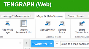
Case No 11518 - The TENGRAPH Web "Maps & Data Sources" links to GeoVIEW (Geology and WAMEX) have been upgraded.
Case No 11599 - Perth Urban Area - Results Display Improved
Case No 11557 - Extra map scales options have been added when printing a map.