The National Drilling Initiative (NDI) aims to drill multiple holes in a region. These holes will map the regional geology and architecture and also define the potential for mineral systems in 3D.
The Geological Survey of Western Australia (GSWA) is a key participant in MinEx CRC, the world’s largest mineral exploration collaboration. MinEx CRC brings together industry, government and research organizations to undertake geoscience and engineering research. A major project of the MinEx CRC is the NDI, which manages and delivers drilling programs in multiple case study areas across Australia. A range of drilling methods may be used in these programs; however, it is intended that the NDI will take advantage of new, low-cost coiled tubing (CT) drilling technology and associated sensing in order to maximize the number of drillholes and the volume of data collected. These technologies lower the environmental and physical footprint of drilling campaigns.
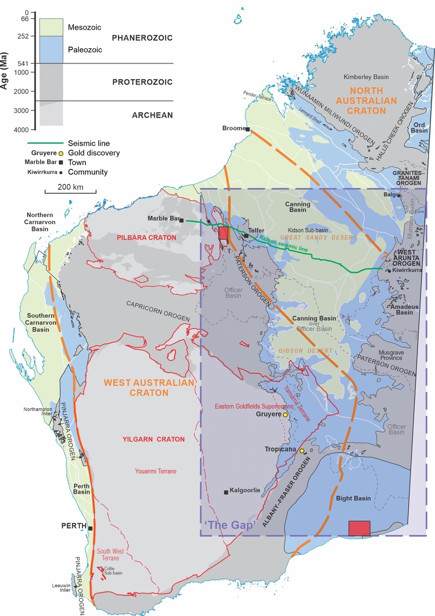
These new technologies are ideal for geological investigations in remote greenfield regions. A key frontier region in Western Australia is the central and eastern deserts. This region, informally named 'The Gap', consists of several basement terranes and craton margins that are covered by younger basins such as the Canning and Officer Basins. Through the Exploration Incentive Scheme (EIS), the Government of Western Australia wishes to increase the geological understanding of these potentially prospective, but poorly understood areas. For this reason, GSWA and MinEx CRC will be undertaking two NDI projects to better understand the ‘The Gap’: Paterson and Eucla projects.
Paterson NDI campaign
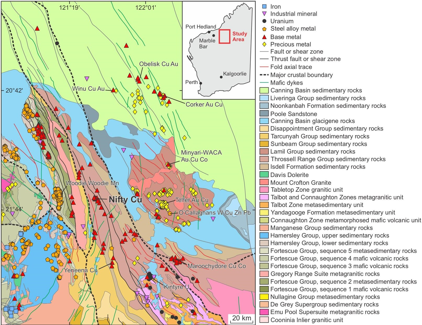
A significant exploration frontier is the Paterson region, an area prospective for sediment-hosted copper and other base metal resources that are critical for the transition to a net-zero carbon emissions future. Understanding the processes that form copper deposits within sedimentary sequences is crucial to future exploration in the region and the State. However, a key challenge in mineral exploration, especially in greenfield regions and under cover, is the transition from regional to deposit scale across to the camp scale. At the camp scale, it can be difficult to detect a mineral system unambiguously, although sufficient predictive datasets to help localize drilling targets are also generally lacking. The Paterson NDI campaign will directly address this challenge.
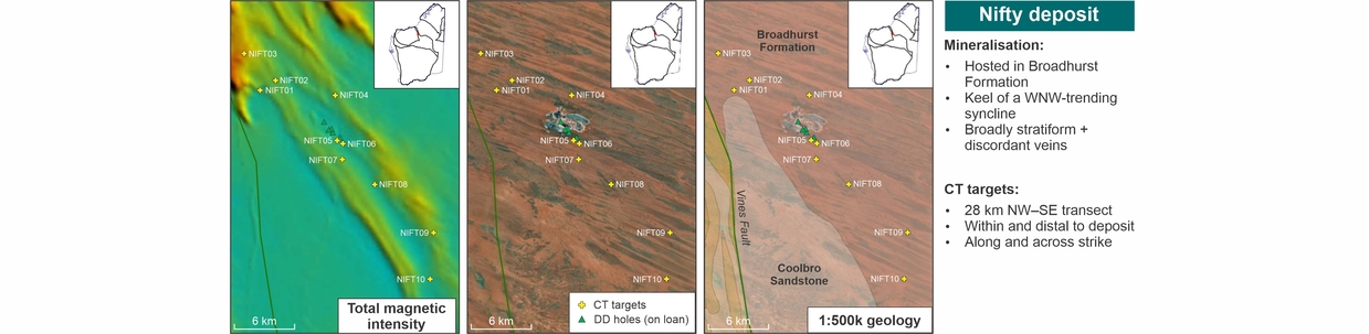
The project area is located within the Yeneena Basin in the northwest Paterson Orogen, east of the town of Marble Bar. Drilling will focus on the broader Nifty copper mine camp region, about 30 km southwest of the Telfer copper–gold deposit. The campaign has been designed to target the mineral system at distances up to 25 km from the Nifty ore body, in areas with identified data gaps.
The proposed drilling program will involve drilling up to 10 stratigraphic drillholes to a depth of about 500 m each. The targets are intended to sample a range of cover and basement geology and mineralization, and to intersect distal alteration facies related to the deposition of the Nifty mineral system. Physical samples and data acquired during drilling will provide new geological, geochemical, petrophysical and geochronological datasets, which will be used to develop models and interpretations of under cover mineral systems. The outcomes of the campaign will benefit the region, Western Australia and Australia, and will support better-informed planning decisions by the government and exploration decisions by industry.
The program commenced in August 2023, with the completion of three near-mine drillholes. The program will recommence after the summer months, with the remaining holes scheduled to be drilled in mid-2024.
Additional information and data will be released as it becomes available.
Eucla NDI campaign
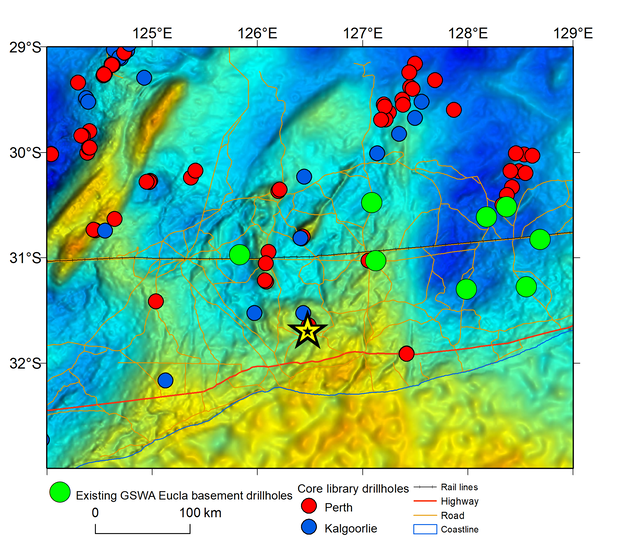
The purpose of the Eucla NDI campaign is to improve geological knowledge in the Eucla region, adjacent to the Eyre Highway, and to test the CT drilling techniques for stratigraphic drilling in covered geological terranes. The Eucla program will test geophysical anomalies in the Madura province and provide a better understanding of how CT drilling might be applied to drill through thick and challenging sedimentary cover. This program will drill up to three drillholes, filling a gap in prior GSWA drilling in the region, and would be conducted in the vicinity of the Moonera homestead. The majority of prior GSWA drilling in the Eucla during 2013–14, was approximately 100 km to the north of the Trans-Australian railway line. The proposed NDI drillholes will intersect the buried Madura Province beneath the Eucla Basin.
This work is part of a long-running, precompetitive geoscience program that has and continues to improve our understanding of the geology and resource potential of the region. The program will focus on the collection of physical samples and downhole data from a series of stratigraphic drillholes up to an approximate depth of 500 m, penetrating through the cover of the Eucla Basin. These drillholes will also further test the use of the CT drilling techniques for stratigraphic drilling in covered geological terranes; the Eucla Basin sediments are known to be particularly challenging for drilling. Drilling is tentatively scheduled to begin in early 2024. Additional information on this program and the data from it will be released as it becomes available.
Contact
For further information, contact:
geological.survey@dmirs.wa.gov.au