Processed data from Canning survey now available online.
| Date: | Tuesday, 17 March 2015 |
|---|
Last year’s Canning Coastal Deep Seismic Survey attracts academic and industry interest.
Data from the Canning Coastal Deep Seismic Survey has attracted international academic attention from universities as far away as Sweden.
The processed data, which is now available online, has generated strong interest from petroleum explorers in the onshore Canning Basin
The data was officially released by Mines and Petroleum Minister Bill Marmion at the Geological Survey of Western Australia’s (GSWA) 2015 Open Day on 27 February this year.
The seismic survey is one of several deep-crustal surveys being carried out collaboratively between DMP and Geoscience Australia as part of the National GeoTransect Program, co-funded by the Federal and State Governments.
“The objectives of this survey are to obtain a better understanding of the subsurface geology of the region, and how the Australian continent was assembled as a result of plate tectonic processes over billions of years,” GSWA Assistant Director Don Flint said.
“Such knowledge obviously assists in identifying areas of petroleum, mineral and geosequestration potential.”
Mr Flint said that all of the processed data could be downloaded free via DMP’s Western Australian Petroleum and Geothermal Information Management System (WAPIMS).
“But it is voluminous, so we have provided the option of supplying the full data package on a hard drive at the cost of the drive only.”
The $3.65 million survey was funded by the State Government's Exploration Incentive Scheme and the data processing was federally funded.
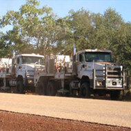
Conducted during May and June 2014, the survey stretched 700 km across the full width of the Canning Basin, along the Great Northern Highway, and the Derby and Gibb River Roads.
Nearly two terabytes of data were recorded by a convoy of about 20 vehicles carrying a crew of about 40 people.
Three specialised trucks stopped every 40 metres and deployed large metal pads to create minute vibrations barely perceptible to people 100 metres away, but capable of penetrating through the crust and upper mantle to depths of up to 50 km.
Reflected seismic energy from each stop was collected by 600 geophones spread over 12 km.
GSWA, with assistance from Geoscience Australia, is now starting a detailed interpretation of the processed data.
Senior Geoscientists Louise Stelfox and Alex Zhan and Senior Geologist Charmaine Thomas with a poster showing results of the survey.