Round 15 of Co-funded Drilling Program announced
| Date: | Friday, 24 February 2017 |
|---|
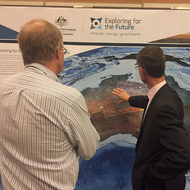
Perth’s geological community turned out in force in Fremantle today to attend the Geological Survey of Western Australia (GSWA) Open Day 2017.
Billed as the premier geological event on DMP’s calendar, the popular annual Open Day is a platform for the latest geological information and major activities undertaken by GSWA.
The Open Day featured presentations on the latest results from GSWA’s geoscience programs, including collaborative research with Geoscience Australia, CSIRO, the Centre for Exploration Targeting, Curtin University, and other partner organisations.
“Thanks to funding through the EIS, GSWA has been able to make tremendous strides in recent years in geoscience and mapping, helping explorers to target new discoveries,” GSWA Acting Executive Director Dr Ian Tyler said.
Round 15 of the Exploration Incentive Scheme’s (EIS) flagship Co-funded Drilling Program was formally announced at the Open Day, offering about $5 million in co-funding for innovative drilling to be undertaken in the 2017–18 financial year.
Round 15 applications will close at 5pm on 7 April 2017.
“Each round of the program is keenly contested by explorers seeking funding and the co-funded drilling program is one of the most visible components of the EIS,” Dr Tyler said.
“However, the breakthroughs and new developments in geoscience, mapping and our business systems owe a great debt to the scheme that we are acknowledging today by showcasing our achievements.”
Dr Tyler said that $130 million had been invested in the EIS since 2009 and now, with Royalties for Regions funding from July 2017, it would continue to receive $10 million a year until June 2020.
The Open Day featured 11 presentations by experts in the associated areas of geology and geoscience, covering a range of areas including the Pilbara, Eastern Goldfields, Musgrave Province, northern Perth basin, the Kimberley Basin and the east Albany-Fraser Orogen.
A highlight this year was the launch of two interactive virtual tours created by DMP geoscientists for viewing with Google Earth – a journey from Marble Bar through the East Pilbara, taking in the remnants of gigantic volcanic eruptions, and a more technical tour of the Youanmi Terrane in the Yilgarn Craton based on a published field guide.
There was also be an extensive poster display and demonstrations of online systems to access data and information.
Other highlights included:
- New mapping releases including areas of the West Capricorn, Murchison, West Musgrave, South Yilgarn, Tanami–Arunta, Kimberley and East Yilgarn.
- The announcement of a seamless geological interpretation of the Eastern Goldfields between Leinster and Norseman, based on published 1: 100,000-scale mapping enhanced by EIS-funded geochronological, geochemical, isotopic and geophysical data.
- News of new digital products being compiled to cover the south-east Capricorn basins, and the Fortescue and Hamersley basins in the southern Pilbara.
- New geophysical survey products, including publicly accessible geophysical datasets.
- Updates on collaborative geoscience projects being carried out in Western Australia in cooperation with the Centre for Exploration Targeting at UWA, Curtin University, CSIRO, and Geoscience Australia.
- A presentation of a collaborative project by CET, GSWA and the Minerals Research Institute of WA that identifies tools for discovering iron ore deposits in the Pilbara Craton.
- New business systems were demonstrated, including the latest updates for GeoVIEW.WA, GSWA’s award-winning geoscientific web application, and a new version of the Western Australian Petroleum and Geothermal Information Management System (WAPIMS).