Updated version accessible on all browsers and mobile devices
| Date: | Monday, 26 August 2019 |
|---|
A new version of the Department of Mines, Industry Regulation and Safety’s (DMIRS) interactive mapping system GeoVIEW.WA will be launched soon.
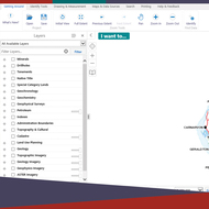
The online GIS-based tool allows users to view, query, and map various geology, resources and related datasets.
The new version of the system will enable it to run in all web browsers and on mobile devices, as it will no longer be dependent on the Microsoft Silverlight plugin.
Executive Director Geological Survey and Resource Strategy Jeff Haworth said the upgrade will maintain the same functionality but there will be changes to the look and feel of the interface.
“Searching using the new version, will now construct a list of search criteria based on details entered through both textual and spatial search screens, and will no longer use the look-up screens of the previous version,” he said.
“This will apply to search tools for mineral exploration reports in WAMEX, drillholes and geochemistry.
“GeoVIEW.WA allows users to construct and print a customized geological maps of a chosen area and scale, which incorporates other mineral and petroleum exploration datasets including mines and mineral deposits, petroleum wells, and active leases.”
For more details and user manuals, use the ‘What’s New’ button after accessing the GeoVIEW.WA system.