The latest geological data on the Tanami region will be available soon on the department’s website
| Date: | Tuesday, 02 January 2018 |
|---|
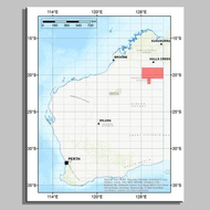
Preliminary geophysical data about the structure of the earth’s crust in the Tanami region will soon be available on the Department of Mines, Industry Regulation and Safety’s (DMIRS) website.
The data, collected in August last year by an airborne gravity survey to help characterise key geological elements of the region, is the result of a collaboration between the Geological Survey of Western Australia (GSWA), a division of DMIRS, and its partner Geoscience Australia (GA), a division of the Commonwealth Department of Industry, Innovation and Science.
GSWA Director of Mapping, Dr Ian Tyler, said the data generated from the survey would be made available through GSWA’s interactive mapping application, GeoVIEW.WA on 9 January 2018.
“GSWA has been acquiring data from airborne surveys since the mid-1980s and we’ve been doing airborne geophysical studies in our own right since 1993, so this is a long-running standard approach to mapping. Airborne gravity is more expensive than ground work by a factor of 50 per cent, but it’s quicker and avoids the need for ground access in areas that are remote and logistically difficult,” Dr Tyler said.
The NE Canning-Tanami project has been surveyed using the GT-2A gravimeter system, which was flown by Thomson Aviation.
The area is a target for sediment-hosted lead–zinc deposits and copper and gold deposits, and for petroleum. “By systematically mapping the State in this way and characterising the regional geology, GSWA and GA hope to provide public data that will de-risk the area for future mineral and petroleum exploration and help companies assess whether or not they want to come to Western Australia.”
The final data will be released by GSWA and GA after verification is complete. For more information please email geophysics@dmirs.wa.gov.au.

