Geological Survey of Western Australia pamphlet guides visitors around Rottnest Island’s sites of geological interest
| Date: | Thursday, 18 June 2015 |
|---|
The Department of Mines and Petroleum’s (DMP) geotourism publications focus on geology, landscape and the mining history of Western Australia.
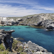
Mention Rottnest and most people think of their annual pilgrimage to the island 20 km off Perth’s shoreline to relax and enjoy a beach lifestyle.
But did you know that "Rotto", as it is widely known, is a geological treasure trove?
Ancient fossil stromatolites, coral reefs, and salt lakes that were once mined are all part of the history of sea-level change over hundreds of thousands of years.
The Geological Survey of Western Australia (GSWA) has released a new pamphlet to guide visitors to locations of geological interest throughout the island.
Rottnest Island – a Geology Guide was published to coincide with a major two-day annual geotourism conference held in Perth and Rottnest late in September 2015.
The 2015 FACET (Forum Advocating Cultural and Eco-Tourism) Conference focused on geotourism that engages and informs people about geology and landscape.
"Rottnest Island tells the story of sea-level change over the last 140,000 years as sea levels fluctuated,” GSWA geologist Jean Johnston said.
Mrs Johnston, who worked on the pamphlet with DMP geologist Bob Gozzard and graphic designer, Murray Jones, said that sea levels had once risen high enough to drown the whole of the island, and sometimes fallen so low that Rottnest was not an island, but a continuation of the mainland.
GSWA Executive Director, Dr Rick Rogerson, said GSWA staff had taken part in a number of geotourism conferences in Australia and overseas since 2008.
"Our work on geotourism products such as the Rottnest Island pamphlet enables tourists to get a greater understanding and enjoyment out of their visits as they travel around Western Australia and see places of stunning beauty and world-class geology," Dr Rogerson said.
"This fascinating Rottnest Island pamphlet follows on the heels of another unusual publication GSWA released late last year, Stepping Stones, that guides geotourists through sites of geological interest in Perth’s CBD."
Stepping Stones is a pamphlet that presents two self-guided trails in the heart of the city.
One trail covers sites such as Ritter’s Pole (the ‘rock kebab’ in Stirling Gardens designed by the late architect Paul Ritter), the Perth Mint and Queens Gardens.
The second trail takes in nearly 20 façades in St Georges Terrace that feature igneous, sedimentary and metamorphic rocks.
"DMP is happy to provide geotourism products that focus on the geology, landscape and the mining history of Western Australia," Dr Rogerson said.
"This work allows us to engage with a wide range of people to present a different view of geology and mining."
Rottnest Island — a Geology Guide and Stepping Stones are both available free of charge via GSWA’s eBookshop.
Hard copies are also available from the information counter at Mineral House, 100 Plain Street, East Perth and from tourist centres in Perth and on Rottnest Island.