The scale bar is located next to the coordinate window, near the bottom left of the main display.
The scale at which you are currently viewing the map is displayed on the right hand side of the coordinate window.
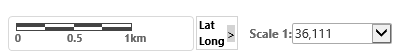
Change the map scale by clicking on the down arrow and selecting from a list of pre-set scales. The scale listed are the same scales increments used by Google Maps and GeoVIEW.WA.
Metric scales are available for selection when requesting printed A4/3 or A1 PDF maps.
Coordinate Window
When TENGRAPH opens, the coordinate panel is minimised.
Clicking on the Lat/Long arrow > opens the coordinate window.
![]()
The information displayed in the expanded coordinate window view are Latitude (Lat) and Longitude (Long) coordinates, Easting (East) and Northing (North) grid coordinates including zone (Z 51), Point Scale Factor (Pnt.S.F.) and Grid Convergence (Grd.Cnv.).
All of these values refer to the current position of your mouse on the map.
Use the Plot Coordinate tool or Print Object Details report to obtain coordinate readouts.