Magnetotelluric (MT) is a passive geophysical technique that measures the natural time-varying electromagnetic fields that pass through the Earth associated with world-wide lightning storms and the interaction of the Earth’s magnetic field with the sun’s solar winds. By measuring these naturally occurring electromagnetic fields the conductivity structure of the subsurface can be understood to 100’s of kilometers depth.
The relationship between these horizontal and mutually perpendicular fields recorded at each station provides apparent resistivity and phase lag information as a function of frequency, commonly referred to as MT response curves. With increasing depth there is an exponential decrease in the amplitude of electromagnetic fields, the so-called skin-depth phenomenon. The depth of penetration (or skin depth) of these fields is directly related to frequency (the lower the frequency, the greater the depth) and the resistivity of the material (the greater the resistivity, the greater the depth). This means estimates of resistivity vs depth can be made beneath each site based on the MT apparent resistivity response curves. However, since the conductivity of the Earth varies from location to location, so the conversion factor from frequency to depth will also vary.
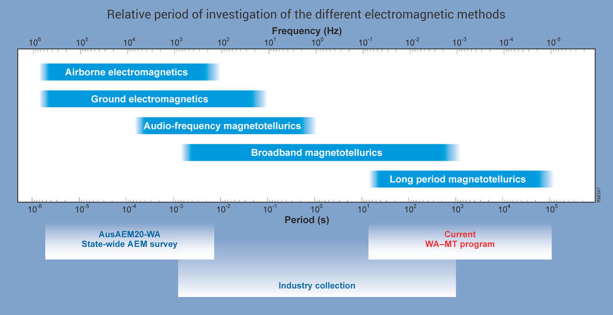
A variety of different passive MT surveying techniques are available for different depths of investigation:
- Audio magnetotellurics (AMT)
- Broadband mangnetotellurics (BBMT)
- Long–period magnetotellurics (LPMT)
AMT methods are typically used for investigating the conductivity variations of the near surface to several kilometers depth, while BBMT methods have the added advantage of also detecting responses down to 10s of kilometers depth. In contrast, LPMT surveys measure responses from depths of several 100 kilometers and provide conductivity information of the lower crust and upper mantle.
Equipment
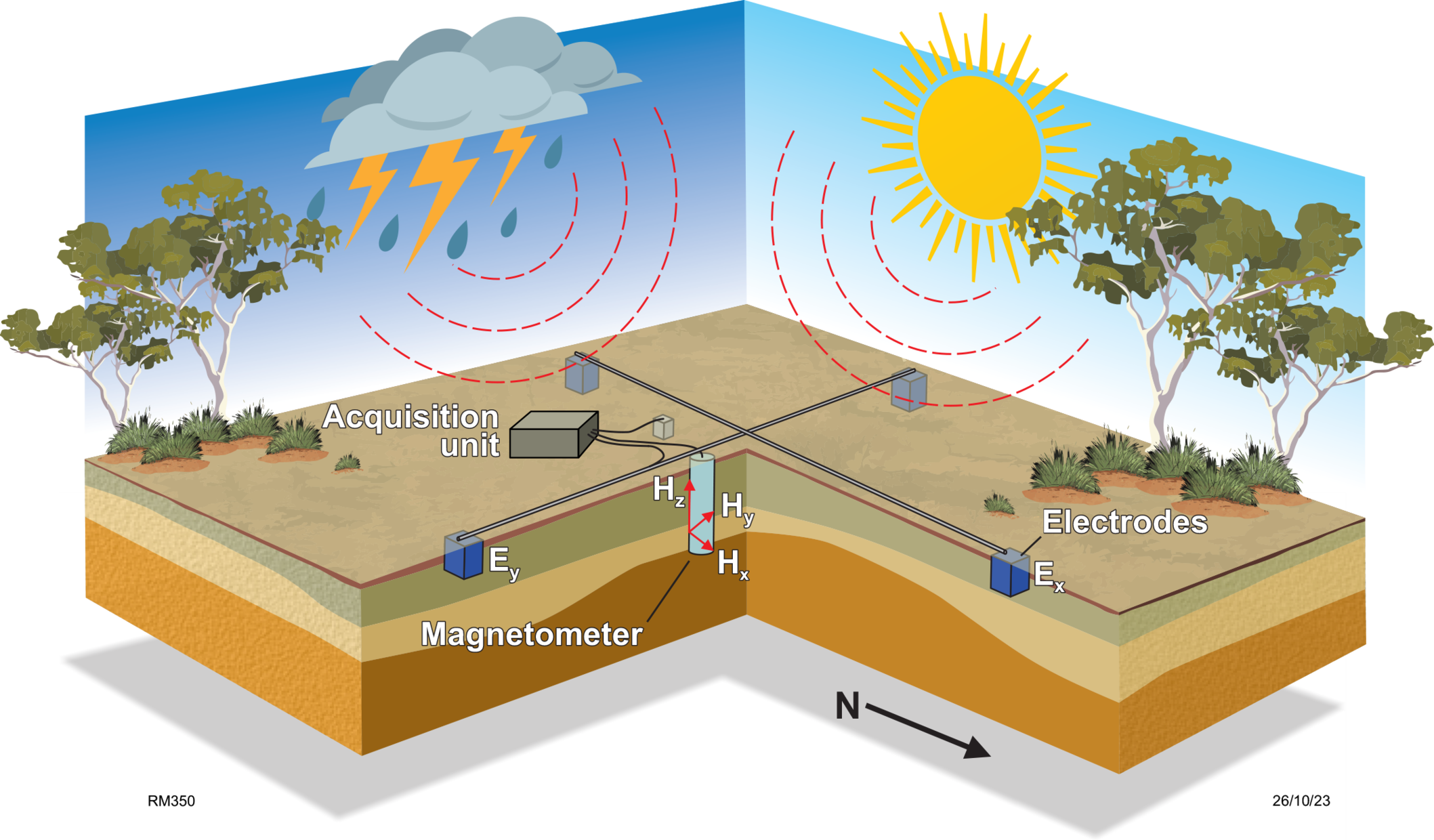
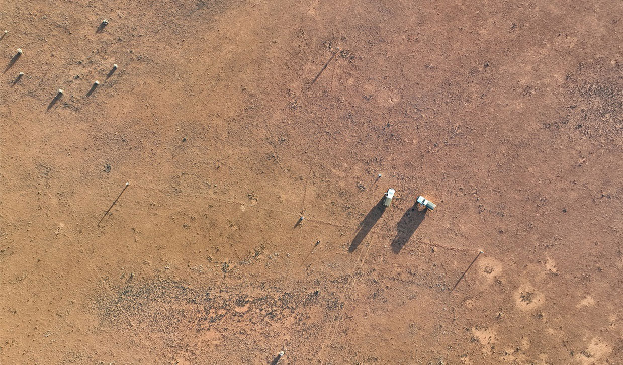
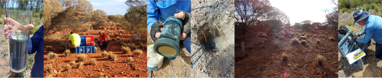
LPMT surveys utilize buried potential field sensors (electrodes) and a magnetic induction sensor (magnetometer) connected to a centralized data logging unit to record natural time-varying electromagnetic fields. A typical site setup will include 4 electrodes pots each buried ~30cm into the ground, spaced 100m apart, and located in a crosshair pattern aligned with magnetic N-S and E-W. A magnetometer is buried within one of the 4 electrode quadrants to a depth of ~50cm, and a grounding electrode is buried close to the center point of the site. All the sensors are connected to a data logger, powered by a battery and solar panel. Equipment is deployed for 3-6 weeks to record data at periods greater than 104s.
Specifically, the electromagnetic field information recorded by LPMT surveys come from the interaction of the Earth’s magnetic field with the sun’s solar winds. The suns solar activity is predicted to increase over the next 3 years which is ideal for the collection of LPMT data used for understanding the Earth’s deep crust and upper mantle.
WA-MT
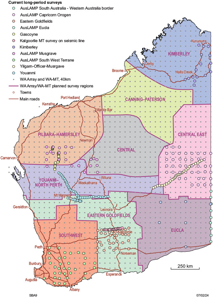
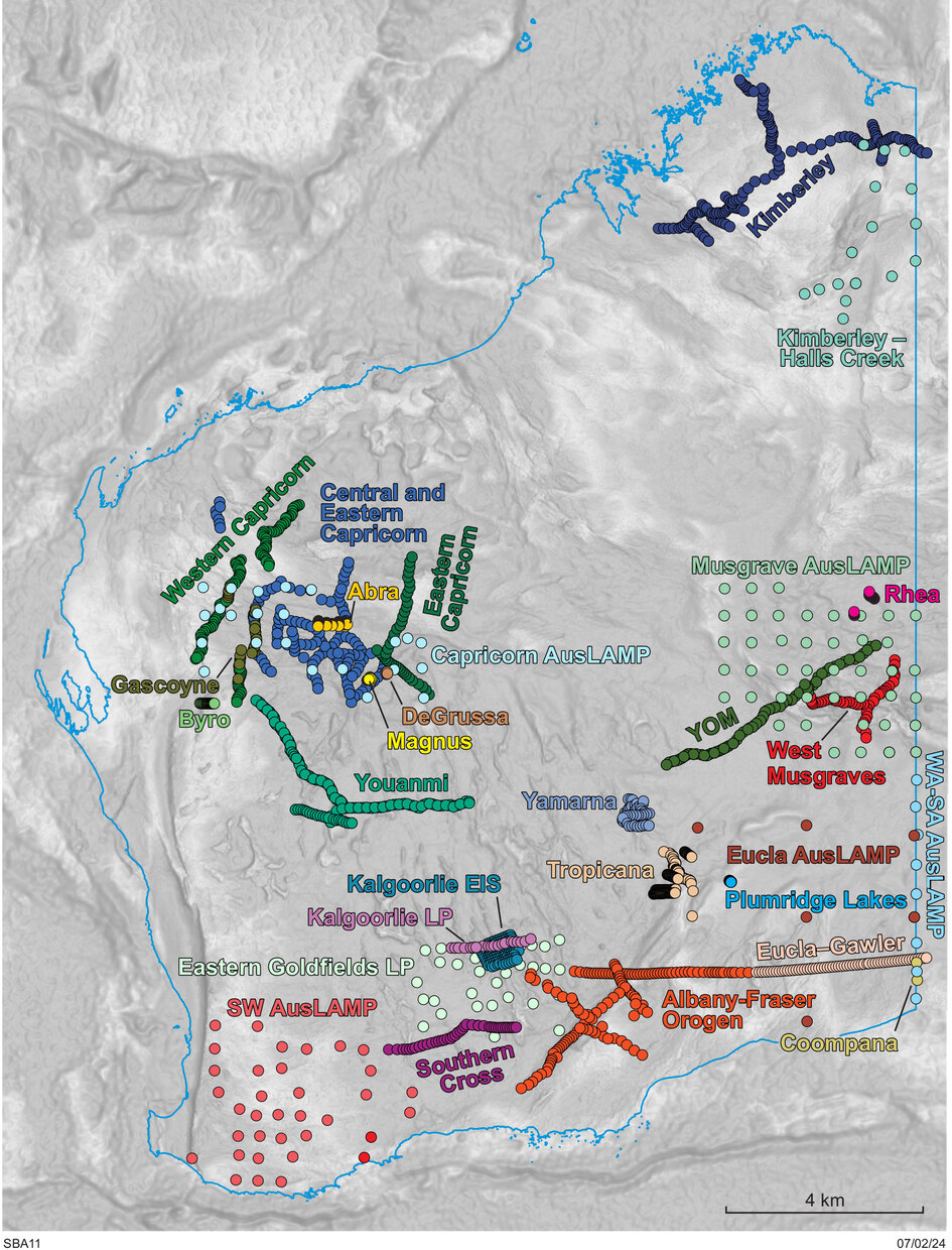
The Geological Survey of Western Australia (GSWA) is acquiring MT surveys in collaboration with the Centre for Exploration Targeting at The University of Western Australia, The University of Adelaide, AuScope and with Geoscience Australia. GSWA has also commenced WA-MT, a program that will aim to cover the West Australian state with MT data by expanding on the Australian Lithospheric Architecture Magnetotelluric Project (AusLAMP), a collaborative national survey which acquires long-period MT data. The WA-MT program involves the deployment of LPMT equipment arranged in a 40km x 40km grid pattern that will coincide with the WA Array passive seismic data acquisition sites. The entire state will be mapped by relocating instruments monthly to progressively cover the nine WA Array regional project areas. The acquired MT data will be made available for geological interpretation of the subsurface by explorers, researchers, and the community.
Western Australia remains under-imaged in this technique. WA-MT aims to provide significant additional information about Australia’s geodynamic framework as well as valuable public data for resource exploration.
Outcomes of this project include:
a) increased pre-competitive geoscience data for reducing exploration risk
b) a world-leading dataset covering the WA state to attract resource investment
c) a lithospheric architecture model complimenting the WA-Array passive seismic project
d) complimentary statewide conductivity data products to the recently acquired statewide airborne electromagnetic survey data across the state.
Publications
-
 MRIWA Report 476
Integrated Multi-Scale Study of Crustal Structure and Prospectivity, Eastern Yilgarn Craton and Albany–Fraser Orogen
MRIWA Report 476
Integrated Multi-Scale Study of Crustal Structure and Prospectivity, Eastern Yilgarn Craton and Albany–Fraser Orogen
-
 Report 189
A magnetotelluric survey across the east Albany–Fraser Orogen
Report 189
A magnetotelluric survey across the east Albany–Fraser Orogen
-
 Record 2014/6
Albany-Fraser Orogen seismic and magnetotelluric (MT) workshop 2014
Record 2014/6
Albany-Fraser Orogen seismic and magnetotelluric (MT) workshop 2014
-
 Report 136
A magnetotelluric survey across the Kimberley Craton, northern Western Australia
Report 136
A magnetotelluric survey across the Kimberley Craton, northern Western Australia
-
 Report 135
A magnetotelluric traverse across the eastern part of the Capricorn Orogen
Report 135
A magnetotelluric traverse across the eastern part of the Capricorn Orogen
-
 Report 121
A magnetotelluric traverse across the southern Yilgarn Craton
Report 121
A magnetotelluric traverse across the southern Yilgarn Craton
-
 Report 114
Imaging crustal structure in the west Musgrave Province
Report 114
Imaging crustal structure in the west Musgrave Province
-
 GA Record 2013/28
Yilgarn Craton–Officer Basin–Musgrave Province Seismic and MT Workshop
GA Record 2013/28
Yilgarn Craton–Officer Basin–Musgrave Province Seismic and MT Workshop
-
 Record 2013/6
Youanmi and Southern Carnarvon seismic and magnetotelluric (MT) workshop 2013
Record 2013/6
Youanmi and Southern Carnarvon seismic and magnetotelluric (MT) workshop 2013
-
 Record 2011/25
Capricorn Orogen seismic and magnetotelluric (MT) workshop 2011
Record 2011/25
Capricorn Orogen seismic and magnetotelluric (MT) workshop 2011
-
 Record 2007/16
Magnetotelluric investigation into the electrical structure of the Capricorn Orogen
Record 2007/16
Magnetotelluric investigation into the electrical structure of the Capricorn Orogen
Contact
For more information contact:
wa.mt@dmirs.gov.au