AusAEM 20km data package of WA Eastern Borders and Kimberley blocks
| Date: | Tuesday, 07 March 2023 |
|---|
Geophysical data release: AusAEM–WA completion — final AusAEM 20km data package of WA Eastern Borders and Kimberley blocks as part of GA EFTF AusAEM Western Resources Corridor survey 2022.
Geophysical data release: AusAEM–WA completion — final AusAEM 20km data package of WA Eastern Borders and Kimberley blocks as part of GA EFTF AusAEM Western Resources Corridor survey 2022.
On Friday 10 March 2023, the Geological Survey of Western Australia (GSWA) and Geoscience Australia (GA) will release the final data package from the AusAEM–Western Resources Corridor (WRC) TEMPEST® Airborne Electromagnetic Survey flown between May and October 2022 by Xcalibur Multiphysics.
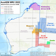
With this data package, GSWA and GA have completed coverage of Western Australia at 20km line spacing over the remaining Eastern Borders and Kimberley areas of the State.
The survey was flown in five blocks extending over parts of Western Australia, the Northern Territory and South Australia. The data package includes areas flown at higher resolution in the Coober Pedy area (5km line spacing) and the Musgraves (variable line spacing from 5km down to 1km in selected areas).
The AusAEM–WRC survey was funded by GA’s Exploring for the Future program, and by the Western Australian Government’s Exploration Incentive Scheme for the 20km line spacing coverage over the State.
The data package, including layered earth inversions by GA and Xcalibur, will be available for download on and after the release date via GSWA’s MAGIX and GeoVIEW.WA platforms by searching on MAGIX registration number 72374, and from Geoscience Australia’s eCatalogue with ID 147688.