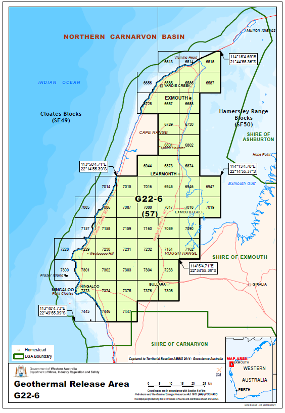
Area G22-6
| Block No | Block No | Block No | Block No | Block No |
|---|---|---|---|---|
| 6656 |
6728 |
6728 |
7014-7016 | 7085-7088 |
| 7157-7160 | 7228-7232 | 7300-7304 | 7373-7376 | 7445-7447 |
| Block No | Block No | Block No | Block No | Block No |
|---|---|---|---|---|
| 6656 |
6728 |
6728 |
7014-7016 | 7085-7088 |
| 7157-7160 | 7228-7232 | 7300-7304 | 7373-7376 | 7445-7447 |
Contains fifty-seven (57) blocks to the extent only that the area is within the State as defined in section 26 of the PGERA.
Special Notices
Applicants should be aware of the following special notices in relation to Area G22-6:
- I, Fiona Knobel, Executive Director, Resource Tenure Division of Department Mines, Industry Regulation and Safety, under delegation from the Minister for Mines and Petroleum, advise that it is intended that a condition under section 91B of the Petroleum and Geothermal Energy Resources Act 1967 will apply to any geothermal exploration permit granted in respect of Areas G22-6 prohibiting the holder from entering upon:
- any offshore islands above the mean low water mark as is included in the permit area.
- Crown Reserves R 27288, R 40079, R 44892, ID M2 – Ningaloo Marine Park, ANCA Wetlands (Bundera Sinkhole, Cape Range Subterranean Waterways and Learmonth Air Weapons Range – Saline Coastal Flats) and File Notation Area FNA 14566, FNA 14570, FNA 15266, FNA 15267, FNA 15802, National Heritage Site - ID 105881, WA Heritage Sites - ID 00837, ID 04231, ID 05491 and World Heritage Area Ningaloo Coast, being areas of high environmental conservation value; and
- land within the Exmouth townsite boundary.
Environmental considerations
This area contains a number of environmental considerations (such as Threatened Ecological Communities, Environmentally Sensitive Areas, and Red Book Areas) which potential applicants should consider when making an application and planning a work program. Operational activities may require consultation with the Department of Biodiversity, Conservation and Attractions, the Department of Water and Environmental Regulation, and the Department of Agriculture, Water and the Environment (Cth). See map provided.
Available data and maps
Contact
For any general enquiries please contact the Resource Tenure team
Email: petroleum.titles@dmirs.wa.gov.au
For data enquiries please contact the Statutory and Resource Information team
Email: petdata@dmirs.wa.gov.au