Description
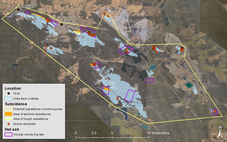
Since the discovery of coal in the Collie Basin in the late 19th century, the resource has been almost continuously mined by underground and open cut methods resulting in a number of abandoned underground mine workings (the collieries). The footprint of these workings is extensive, with some of these now situated within the towns of Collie, Allanson, Collie Burn and Collie Cardiff.
A 1995 Minerals Research Institute of Western Australia Report identified 97 discontinuous subsidence locations above shallow abandoned underground mine workings, extending over a combined area of 72 ha. The 1995 report also states: “it is anticipated that failures will continue to occur in the foreseeable future”. ‘Hot ash’ (carbonaceous shale) occurrences, which may represent an elevated fire risk, have also been reported in the region.
The Collieries project will extend across the Collie Basin identifying areas of high risk to the community and facilitate development of remediation approaches. New thermal camera technologies now available on drones provide a new stream of investigation, allowing for rapid interrogation of sites. Geotechnical, photographic and thermal data capture investigation will increase understanding of Collieries features susceptible to subsidence, as well as “hot ash” threat recognition.
Strategic Objectives
- To establish a consistent approach to assessing risks associated with ground subsidence and carbonaceous shale in the Collie Basin, which will inform a prioritisation methodology to address risks to the community.
- To develop and implement (based on risk to the community) appropriate rehabilitation strategies for the Collie Basin relating to ground subsidence and near surface carbonaceous shale.

| Desktop assessment | Investigation | Planning | Implementation | Monitoring |
|---|---|---|---|---|
| Collation of all records (DEMIRS, Department of Biodiversity, Conservation and Attractions, Shire of Collie) relating to ground subsidence and ‘hot ash’ 2022-2023 (C) | Geotechnical investigation targeting high priority subsidence locations 2024-2025 (P) | Project plan 2023 – 2024 (U) | Declaration of abandoned mine site (pilot locations) 2024 (P) | Monitoring of environmental indicators to ensure the site has met objectives for post-project landuse (at minimum the site is safe, stable and non-polluting) (P) |
| Stakeholder engagement commenced 2023 and are ongoing (U) | Assess efficacy of subsidence capture methods 2024-2025 (P) |
Stakeholder communication plan 2024 – 2025 (P) |
Subsidence rehabilitation works (pilot locations) 2024 – 2029 (P) |
Revocation of declaration of abandoned mine site (P) |
|
Preliminary Project Plan 2023 – 2024 (U) |
Hot Ash geochemical investigation assessing site characteristics 2024-2025 (P) |
Create opportunity for Aboriginal business / employment 2025 - 2029 (P) |
Hot ash rehabilitation works (pilot locations) 2025 – 2028 (P) |
|
| Comparison of subsidence issues within Collie Basin area with other domestic and international sites 2024 (U) | Ground truthing of subsidence data set to remove duplicate records 2024-2025 (P) | Geotechnical remediation options for subsidence rehabilitation (pilot locations) 2024 - 2029 (P) | ||
| Determine appropriate assessment techniques and remediation strategies 2024 (U) | Evaluate hot ash geochemical capture methods and best-practice treatment options 2024- 2025 (P) |
Schedule: Completed (C); Underway (U); Planned (P)