The State of Western Australia, together with State waters and the Western Australian Offshore Area (Commonwealth waters), are divided into graticular sections. Each section is five minutes of latitude by five minutes of longitude. These graticules constitute the building blocks for all exploration and production titles.
Graticular sections
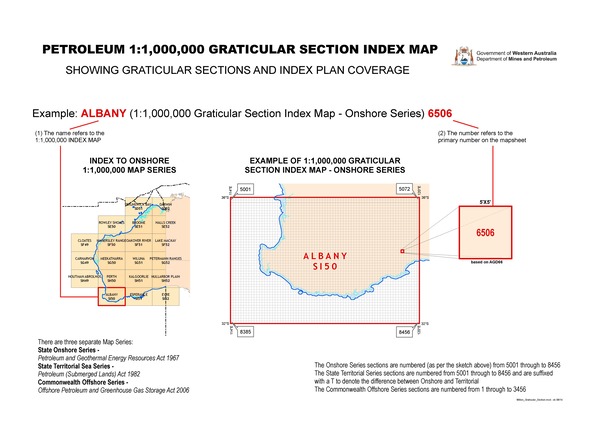
The entire State of Western Australia, together with adjacent areas, is divided up into a series of 1:1 000 000 map sheets. Each of these map sheets is four degrees of latitude by six degrees of longitude. Each map sheet has a common name such as Hamersley Range and also an index name SF 50 this is the horizontal code: SF and the zone in which the sheet is in: 50.
These Map Sheets are comprised of 3456 graticular sections which, as mentioned before are five minutes of latitude by five minutes of longitude. The sections are defined on the Australian Geodetic Datum 1966, (AGD66).
Each section has an average area of about 78 square kilometres. Sections to the north of Western Australia have an area of about 84 square kilometres, while sections to the south have an area of about 70 square kilometres. The difference is brought about by the convergence of meridians of longitude between the Equator and the South Pole.
Within a map sheet, each section is individually numbered starting at the top left and working across and down (just as you would read a book).
The million series map sheets are split into three separate series:
1. Offshore series
To depict Petroleum Titles within the jurisdiction of the Commonwealth Offshore Petroleum and Greenhouse Gas Storage Act 2006. The section numbers for this series are numbered from 1 to 3456.
2. State onshore series
To depict Petroleum Titles within the jurisdiction of the Petroleum Geothermal and Energy Resources Act 1967. The section numbers for this series are numbered from 5001 to 8456.
3. State territorial sea series
To depict Petroleum Titles within the jurisdiction of the Petroleum (Submerged Lands) Act 1982. The section numbers for this series are also numbered from 5001 to 8456. To denote the difference between this series and the State Onshore series these sections are suffixed with a ‘t’.
Please note: The Department of Mines, Industry Regulation and Safety ceased to be a Designated Authority under the Offshore Petroleum and Greenhouse Gas Storage Act 2006 on 1 January 2012. For all queries regarding administration of Commonwealth Titles refer to the National Offshore Petroleum Titles Administrator website.