The Geological Survey of Western Australia (GSWA) focuses on regional field mapping, acquiring regional geophysical surveys, detailed basin and energy studies, and targeted mineral resources projects. GSWA enhances its work by collaborating with external organisations.
The image below shows the areas where GSWA is working. You can find a detailed breakdown of GSWA’s projects in the Geological Survey work program 2022–23, and a list of recently completed collaborative research projects in the Geological Survey Annual Review 2020–21. The numbers on the image correspond to GSWA’s project areas. The GSWA Open Day showcases the latest results from its geoscience programs.
Find results from the Accelerated Geoscience Program in Accelerated Geoscience Program extended abstracts, 2021.
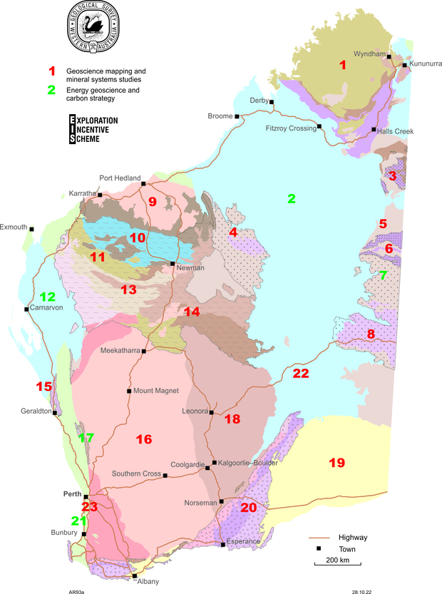
- Kimberley: geochronological, isotopic, metamorphic and mineralisation studies; stratigraphy, geochemistry and volcanology
- Canning Basin: studies of petroleum systems; deep crustal seismic line; lithostratigraphic studies of Ordovician, Devonian and Permo–Carboniferous rocks; sequestration studies of western Canning Basin; Canning Basin baseline earthquake monitoring
- West Tanami: stratigraphy, geochronology, regolith mapping; REE mineralisation studies
- Paterson: geochronological, isotopic and mineralisation studies; regolith mapping; multi-themed integrated geoscience studies; MinEx CRC NDI drilling
- Ngururrpa: gravity capture; regolith sampling and geochemistry
- Aileron and Warumpi Provinces: geochronological, isotopic, metamorphic and mineralisation studies; regolith mapping
- Amadeus Basin: field mapping; basin-wide lithostratigraphic, structural and geochronological studies; stromatolite biostratigraphy; geophysical interpretation
- West Musgrave Province: multi-themed integrated geoscientific studies and modelling
- Pilbara Craton: GIS capture of existing geoscience data; passive seismic investigations into lithospheric architecture in the eastern Pilbara
- Fortescue and Hamersley Basins: integrated geochemical, isotopic and geochronological study of igneous and sedimentary rocks
- Ashburton Basin: geochronology, stratigraphy and mineralisation studies
- Carnarvon Basin: Permo–Triassic biostratigraphy and source-rock studies
- Capricorn Orogen: field mapping; integrated geological, geochronological, geochemical and prospectivity studies
- Eastern Capricorn basins: GIS capture of existing geoscientific data
- Kalbarri National Park: Kalbarri Unearthed – A guide to the geology of the Kalbarri area
- West Yilgarn: geochronological, isotopic, metamorphic and mineralisation studies; regolith mapping; SWAN seismic hazard monitoring and Region 1 of WA-Array, South West Yilgarn
- Moora Basin: evaluate age and hydrocarbon occurrences
- East Yilgarn: field mapping; integrated geological, geochronological, geochemical and prospectivity studies; stratigraphic revision; Eastern Goldfields seismic monitoring
- Eucla basement: integrated geophysical and geological studies from drillcores
- Albany–Fraser and Yilgarn margin: geochronological, isotopic and mineralisation studies, integrated geophysical and geological studies
- Perth Basin CO2 storage: evaluation and analysis of Triassic and Jurassic successions for geosequestration potential; evaluation and analysis of petroleum systems and coal resources
- Far East Yilgarn: multi-themed integrated geoscientific studies; MinEx CRC NDI drilling
- Darling Fault: geochronological, isotopic and metamorphic studies
Statewide:
- WA-Array: major passive seismic data acquisition
- Petrophysics: systematic petrophysical measurement of drillcore samples from significant mineral deposits, poorly explored regions, and reference stratigraphic drillholes
- State maps and statewide datasets: View the most up-to-date spatial geoscience layers on this page
Contact
For more information contact:
geological.survey@dmirs.wa.gov.au